Research Article > DOI
Javier Ortega  , Savvas Saloustros , Mislav Stepinac , Pablo Sanz-Honrado , Fernando Ramonet , Mati Ullah Shah , Katrin Beyer , Sofia Aparicio
2026 | Volume 1 | e004
Received: 16 February 2026 | Revised: 10 April 2026 | Accepted: 5 May 2026 | Published: 22 May 2026
Abstract
The article reflects on the role that robotics, automation and digital technologies can assume in the context of evaluating the physical condition and structural integrity of masonry heritage structures. The main research motivation is that all these processes, from structural surveying and inspection to computational modelling and structural assessment, can be improved with these disciplines that have gained great importance in recent years. Recent research shows that progress in mechatronic systems and digital technologies can help in reducing the time cost, at the operational and data processing level, enhancing the practicability and applicability of inspection systems, as well as in reducing uncertainties at the level of interpretation, processing and analysis of data. The main objective of the article is to identify: (1) recent solutions that built on these disciplines for solving surveying inspection challenges of cultural heritage structures; (2) strategies on the use of digital technologies to develop advanced computational models for structural analysis that consider the detailed structural information collected during inspection, e.g., geometry and masonry microstructure, material properties and damage. The focus is placed on works showing advances that can improve our ability to perform structural diagnosis and analysis of masonry heritage structures, particularly through the onsite characterisation of the masonry inner morphology and the integration of this information into numerical models.
Keywords
cultural heritage, structural diagnosis, non-destructive evaluation, mechatronic systems, artificial intelligence, UAV, digital twins
How to Cite: Ortega J, Saloustros S, Stepinac M, Sanz-Honrado P, Ramonet F, Shah MU, Beyer K, Aparicio S. Recent advances and challenges in the field of mechatronic systems and digital technologies for structural surveying, inspection and assessment of heritage masonry structures. Resilience and Reuse in the Built Environment. 2026; 1:e004.
Download .RIS Download .BibTeX
Link: doi
Introduction
Safeguarding our architectural masonry heritage is a key factor for Europe’s social cohesion, cultural identity, economic growth and sustainability [1]. Thus, it is a major societal demand but also a big challenge, particularly due to the high seismic vulnerability of existing masonry structures. Their conservation involves a unique set of challenges that stem from trying to maintain a balance between respecting heritage values and ensuring structural safety, and having little to no information on the existing historic structure. The success of any intervention on an existing structure requires a proper understanding of the unknowns and uncertainties about aspects such as materials, geometry, structural detailing, loading conditions, and existing damage. Additionally, any investigation should be carried out in a manner that is least invasive, aiming to protect the valuable fabric.
In this context, the role of inspection tasks is essential because they can provide data to inform subsequent structural analysis and/or any decisions for intervention on the existing buildings. The article reflects on how we can improve our current surveying and inspection techniques for heritage masonry structures, focusing on the advantages and disadvantages of some of the disciplines that have gained more scientific attention in recent years. In the first part of the article, we look into the role that automation of Non-Destructive Testing (NDT) systems, specifically through the development of mechatronic systems, can play in this matter, particularly aiming to reduce time consumption and enhance the applicability of current structural diagnosis and evaluation methods. Then, we present state-of-the-art applications of the most widely used mechatronic system, which are Unmanned Aerial Vehicles (UAVs) for surveying and documenting architectural assets. In recent years, their use has become widespread in the sector of cultural heritage because of cost and time efficiency. Lastly, we overview past and current practices to contemplate the possibilities of integrating the information obtained from the above mechanical and geometrical inspection techniques into digital replicas, aiding the structural assessment of built heritage structures. The main challenge is to go beyond the mere geometric digital representation of an asset by allowing decision-making in predictive mode through associating the physical object with its digital replica, that is, its digital twin.
The article thus focuses on the multi-stage and multi-disciplinary processes necessary to evaluate the physical condition and structural integrity of masonry heritage structures. The workflow covers structural surveying and inspection using mechatronic systems and UAVs, to numerical modelling and analysis for structural diagnosis. Whereas the independent use of the different processes involved in the workflow has been widely studied in the literature, there are limited studies intertwining all of them with the common goal of providing a comprehensive structural assessment of historic masonry structures.
In particular, the authors identified a research gap in the limited ability of current 3D reconstructions of historical buildings to represent the internal morphology and damage of masonry, despite the crucial role of this information for numerical analyses and structural assessment. The research methodology adopted for the present article consists of a flexible narrative review based on the authors’ experience, aiming to identify past works that have applied mechatronics and integrated NDT data into numerical models for the structural diagnosis and analysis of heritage masonry structures. The objective is to organise scattered information and contribute to the consolidation and definition of a multi-stage process for structural surveying, with a focus on the documentation, structural characterisation, and realistic modelling of the microstructure of masonry and the inner condition of masonry components.
Mechatronic systems for the non-destructive evaluation of masonry heritage structures
The use of mechatronic systems for inspection processes has gained significant attention in recent years within the transport infrastructure sector [2]. However, in the domain of cultural heritage, it remains a relatively emerging area of research [3-5]. Recent studies emphasise the promising role of service robots fitted with advanced sensors and instrumentation for cultural heritage applications [6], although their practical implementation in this field is still limited. The most common application of robots and drone systems in cultural heritage structures is for 3D surveying and visual inspection [7-11]. The automation of NDTs using robotic systems that are not image-based is still a limited research area, particularly in the field of masonry structures.
This section presents the capabilities and potential of using mechatronic inspection systems based on wave propagation methods (acoustic or radar), which are able to penetrate through the material, to obtain information about the interior condition of masonry structures and their microstructure. Figure 1 shows a graphic summary of the type of systems addressed in the present review, focused on automating the inspection procedure at the level of wave emission (different types of robotic platforms able to emit the penetrating wave) and wave acquisition (remote sensing systems and wireless sensor networks), to characterize key structural parameters, such as inner damage, inner morphology, stress level or mechanical properties.
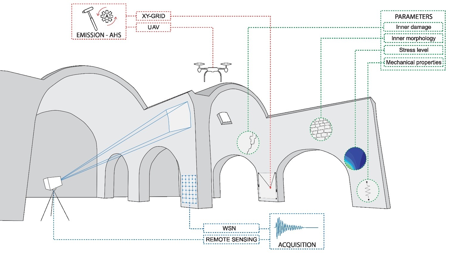
NDT based on wave propagation methods are the only way to obtain information about the inner morphology of historic structures, detect inner damage and its extension or estimate material properties, without inflicting any damage to the structure. Nonetheless, their practical application remains limited due to the absence of standardised protocols, the complexity involved in their implementation and interpretation, and the significant amount of time required for both field operations and data processing. Despite the progress in the field, we are still using similar manual procedures, technology, and equipment, e.g. Ground Penetrating Radar [12-14] and acoustic methods, namely sonic [15-16] and ultrasonic [17-18].
Sonic tests have been preferred instead of ultrasonic ones due to the limitation of ultrasonic waves to penetrate heterogeneous materials like masonry, where high-frequency waves rapidly attenuate when going through discontinuities [19]. The lower frequencies generated by the impact of a hammer, or a similar hitting device, allow the waves to penetrate deeper into the material, even though they offer a lower resolution. Sonic inspections are thus particularly valuable for masonry with previous research showing sound correlations between the sonic wave propagation attributes and several key structural parameters, e.g., inner morphology [20-21], material properties [22-24] or damage [25-26].
Among sonic inspection methods, tomographic imaging stands out for its considerable potential, as it enables internal mapping of materials and cross-sectional visualisation. This approach allows the identification of defects or discontinuities in a non-invasive manner. However, tomographic inspection in masonry structures is typically carried out manually. Given the need to collect a great amount of data to carry out the tomographic reconstruction, this becomes an important limitation to inspect large components of a building and one of the main reasons why its use is limited in practice.
The automation of acoustic inspection procedures—encompassing both signal emission and reception—has recently become a focus of research in the assessment of concrete structures, to identify defects and evaluate structural integrity [27-30]. Likewise, automated impact-based devices have been developed to detect debonding or detachment in tiled surfaces [31-32]. Concerning the reception system, its automation has been recently explored with remote sensing technology and wireless sensor networks (WSNs). Remote sensing equipment, e.g., scanning laser vibrometers, can measure vibrations (velocities and displacements of points) from a distance, i.e., up to tens of meters. Its application in the field of conservation of structural diagnosis of the built heritage is limited to some examples that used it to measure displacements at bridges [33-34] or to perform ambient vibration testing [35-39]. At a smaller scale, these techniques have also been employed for the non-destructive evaluation of artworks [40].
The use of WSNs to monitor different parameters in Cultural Heritage has been widely used. WSNs consist of distributed, wirelessly enabled embedded devices capable of employing a variety of electronic sensors. They can be deployed at different points of infrastructure for Structural Health Monitoring, as has been shown in several works for bridges [41-42] and, more recently, in the field of cultural heritage [43-47]. These systems have great potential because of the lower cost of the technology, the wireless connections, and the fact that they are easily scalable. A performance evaluation of different routing topologies of WSNs in a cultural heritage site was done in [48]. The historical site selected was San Juan Bautista church in Talamanca de Jarama (Madrid, Spain), where a WSN was deployed to monitor different parameters for more than one year [49].
Moreover, in recent years, the Internet of Things (IoT) paradigm has proven to be particularly suitable to support the conservation of cultural heritage. With the concept of the IoT, new communication protocols and new technologies are appearing that can be very useful in cultural heritage, from the monitoring of individual objects to the complete monitoring of buildings. IoT could be very important to simplify the practical application of current standards of preventive conservation or to predict the degradation of objects based on the information gathered. This is the case of the ARGUS Horizon Europe project, which aims to integrate monitoring sensor data and machine learning algorithms for the early detection of anomalies, prioritisation of risks, and, as a result, make management decisions for conservation [50]. Recent work within the ARGUS project has shown how long-term IoT-based monitoring combining fixed sensor networks with mobile robotic inspection can effectively support preventive conservation in fragile subterranean heritage environments such as the underground wine cellars of Baltanás [51]. Furthermore, real-time IoT approaches could be crucial to contribute to short- and long-term conservation, for example, minimising the impact of humans (tourism, vandalism, etc.) and accidents (fires, water leaks, etc.). IoT is focused on having less consumption, higher coverage, lower cost, and easier deployment [52]. Therefore, the use of IoT is becoming very useful also for people not specialised in technology deployment.
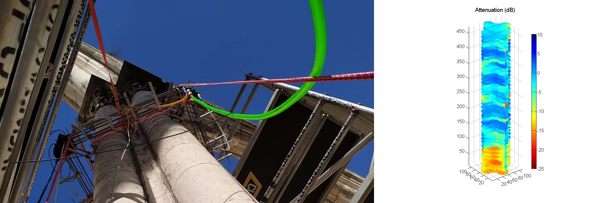
Two recent experiences of the authors have focused on developing an automated system combining the previously discussed technologies to perform acoustic tomography inspection of historical structural elements. Firstly, a new versatile and geometrically reconfigurable ultrasonic tomography system was designed to inspect and obtain information about the internal structure and inner damage of columns in heritage buildings [53]. The proposed system automated the inspection process, enabling the acquisition of multiple tomographic slices along the height of several masonry columns at the Convent of Carmo (Figure 2). By significantly reducing the inspection time, a large amount of data could be collected, which allowed the creation of detailed 3D tomographic images of the entire columns. The inspection of a 6 m height column with more than 8,000 measurement points was made in four hours. The information was essential to assess the overall degradation state of the columns.
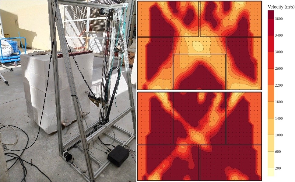
A second innovative automated sonic tomography system was developed to inspect and characterise the internal structure and damage of historic masonry walls [54]. The system integrates a Cartesian robot capable of moving an impact device within a vertical frame measuring 0.9 × 0.5 m along the X, Y, and Z axes, thereby generating the sonic excitation. It can be coupled with different types of data acquisition systems for signal reception. Initial validation was carried out under laboratory conditions using a scanning laser vibrometer to capture the response, enabling full automation of the inspection process (Figure 3a). Several masonry walls of different geometries (and dimensions of approximately 60-70 cm long, 40-50 cm thick and 80-90 cm high) were inspected, and a full inspection of each wall (consisting of an average of 1,500 measurement points) could be done in less than 2 hours, generating tomographic images of the cross-section of the wall at different heights (Figure 3b). Automating the inspection also allows carrying out inspections simultaneously with mechanical testing, e.g., cyclic uniaxial compression tests. A recent investigation aimed to study the variations of tomographic imaging under loading cycles of increasing amplitude, evaluating the sensitivity of sonic inspections to measure damage and stress level of masonry components over time [55]. These two experiences highlight the potential of automating the inspection to enhance the results obtained from existing methods, such as the tomographic technique, obtaining quantitative information about the interior of heritage structures.
Although tomographic imaging techniques are effective for examining the internal morphology of masonry elements, the level of detail they provide remains limited. Results provide smeared velocity or attenuation maps that are complex to interpret, and demand high expertise. The application of Artificial Intelligence in cultural heritage is increasing every day and can be particularly meaningful to improve data post-processing and interpretation. For example, the application of Deep Learning (DL) algorithms for tomographic reconstruction has recently been applied in the construction field to detect flaws and rebar position in concrete elements [56-58], and also in the geophysics field [59-60], showing promising results. However, there is limited experience in the field of masonry [61]. The development of data-oriented algorithms to map inner boundaries, detect and classify flaws within masonry elements directly from acoustic data would require a large dataset, but could significantly aid in the interpretation of results. Their use can provide enriched and more detailed information about the interior of historical construction elements, e.g., cracks, inner morphology, voids, etc. Such information is essential for the structural diagnosis and assessment and, eventually, to make informed decisions on how to intervene.
Automated NDT inspection systems ensure precise, reproducible measurements for the inspection and characterisation of infrastructure, reducing inspection times and improving reliability. Still, one of the main limitations of existing automated NDT inspection systems, including the previous experiences described, is their limited scale, preventing them from effectively covering large infrastructure, e.g., a full façade or a whole heritage building.
Different solutions have been proposed to address local accessibility. Hoxha et al. [62] proposed two omnidirectional robotic systems for inspecting concrete deck surfaces (i.e., concrete floors). Both platforms incorporated a vision-based positioning module, but differed in the NDT technique they carried: one robot was equipped with an automatic impact-echo (IE) data-collection system, while the other integrated a GPR antenna mounted beneath the chassis for automated GPR acquisition. In a subsequent study [63], the authors combined these two systems into a unified multi-sensor robotic platform capable of performing both IE and GPR inspections.
Similar developments exist for vertical surfaces. Nishimura et al. [64] introduced a propeller-type wall-climbing robot capable of performing simultaneous visual and hammering inspections, with crack width estimation and acoustic differentiation between sound and defective areas. Likewise, Zhang, Huang, and Guan [65] proposed a UAV-mounted wireless air-coupled GPR system that collects subsurface data autonomously without requiring surface contact. The lightweight high-frequency radar is integrated into a hybrid aerial–ground robot for stable, high-speed data acquisition and is paired with an enhanced YOLOv5 (You Only Look Once) model equipped with Efficient Channel Attention for real-time subsurface defect detection. Several other GPR wall-climbing robots for vertical concrete inspection have also emerged [66-70].
However, all these systems share a key limitation: they operate locally and therefore cannot achieve the coverage required for full façade inspection. For large-scale surfaces, a fundamentally different approach is needed—one capable of rapid, precise movement across wide areas.
For such applications, automated positioning systems such as planar Cable-Driven-Parallel-Robots (CDPR) [71]. CDPRs consist of multiple cables, each controlled by actuators to adjust their length. These systems have demonstrated high payload capacities with minimal moving parts, making them highly efficient for certain applications. The low inertia of cables allows the end-effector to achieve higher accelerations, resulting in fast movement across large areas [71]. CDPRs are particularly advantageous due to their high payload-to-weight ratio, large workspaces, and ease of transportability [72].
While CDPRs have diverse applications in the medical [73-74] and industrial [75] fields, their application in the construction sector is limited, e.g., window cleaning on façades [76-77] and green wall maintenance [78]. Nevertheless, they show great potential for NDT of large infrastructure. This includes building facades, dam walls, and other expansive structures, where CDPRs can be deployed to inspect areas that are difficult to access with traditional methods. Their ability to traverse large, complex architectural geometries quickly makes them a powerful tool for large-scale NDT inspections. Thus, CDPRs could revolutionise the NDT process for these structures, ensuring efficient and precise inspection, improving safety, and reducing the time required for such tasks, particularly in environments that are otherwise challenging to navigate. In line with this perspective, Alsuhaibani [79] highlights automated robotic inspection systems as one of the most promising future directions for advancing NDT of externally bonded fibre-reinforced polymer systems, further reinforcing the importance of scalable robotic platforms such as CDPRs.
Recent work [80] showed the development of a CDPR equipped with a mobile impact platform capable of performing automated sonic emission and tomographic inspections on masonry and rammed‑earth structures. The system was successfully deployed at the Bermeja Towers in the Alhambra, showing its ability to generate and receive sonic waves across large surfaces and to support 2D/3D tomographic analysis of internal material conditions. The associated control software for this robotic system has been made publicly available in [81], enabling reproducibility and further development within the research community.
Building on these initial results, the system was later deployed at full scale in the Torre de la Vela, as reported in [82]. In that campaign, the CDPR enabled the acquisition of more than 16,000 valid sonic ray paths through a 16-accelerometer array, producing detailed 3D tomographic reconstructions that revealed internal heterogeneity, deep cracks, voids, and interfaces between original rammed earth and later brick masonry repairs.
Complementary inspections using GPR [83] provided high‑resolution information on shallow internal features such as material layering, cavities, and highly reflective inclusions. The same cable‑driven robot allowed GPR measurements at heights of approximately 20 m on the Torre de la Vela without scaffolding, ensuring full monument visibility for visitors during the inspection. Together, the sonic‑tomography and GPR results confirm that automation can drastically improve data‑acquisition density, allow access to previously unreachable areas, and deliver a more complete structural diagnosis of heritage walls, eventually enabling precise and minimally invasive conservation strategies.
Another research path with great potential to improve the scalability and accessibility of NDT inspections is to mount inspection systems in UAVs. Mounting hammering systems in UAVs has already been applied for inspecting large infrastructure [84-85], showing great potential. Udell and Kamel [86] have developed a UAV platform that can be equipped with different contact-based NDT systems (e.g., ultrasonic transducers), which can greatly enhance inspection capabilities. Pfändler et al. [87] demonstrated the feasibility of autonomous, contact-based NDT on reinforced concrete using a hexacopter equipped with two specially designed probes capable of measuring half-cell potentials and concrete electrical resistivity. Their system incorporates self-monitoring features to ensure reliable contact during flight and was successfully validated on a concrete bridge, highlighting the strong potential of UAV-based corrosion assessment to detect early-stage damage and enhance large-scale autonomous inspections. Such systems can become an important solution to reduce the time consumption of existing systems and highly enhance accessibility to any part of the structure. Furthermore, recent studies [88] have also identified UAV-based acoustic impact testing as a promising future direction, supporting the growing interest in airborne NDT solutions capable of reaching complex or hazardous areas with minimal human intervention.
Unmanned Aerial Vehicles for structural surveying and inspection
UAVs have undergone rapid advancements lately. They are becoming increasingly lighter, smaller, and better equipped. They now feature long-lasting batteries and enhanced control and stabilisation systems, enabling improved flight performance and data capture capabilities. In addition, thanks to various intuitive features, they have become highly user-friendly even for non-professionals.
UAVs are extensively utilised in various sectors (i.e. agriculture [89-90], forestry [91-92], logistics [93]) and are also becoming extremely important in construction and engineering [94-95], architecture and urbanism [96-98], and disaster management sectors [99-104]. Moreover, UAVs are instrumental in capturing spatial data over expansive areas, facilitating risk assessment and damage detection, particularly following seismic events such as earthquakes [105]. Their ability to capture high-resolution imagery (including the use of infrared and multispectral cameras), collect data, and access hard-to-reach areas has made them invaluable assets and has revolutionised the fields of building inspection and documentation.
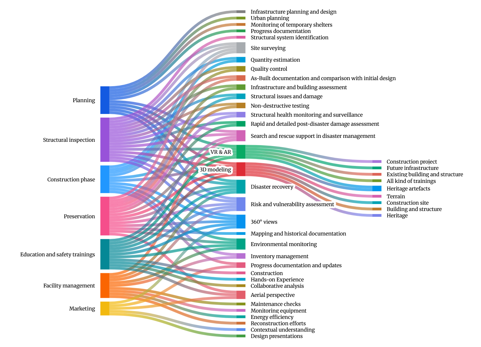
UAVs offer several advantages over traditional inspection methods, including enhanced safety, lower cost, and time efficiency. The ability to generate high-quality documentation places UAVs at the forefront of technological innovations and the future of heritage preservation and conservation. Figure 4, in the form of a Sankey diagram, shows state-of-the-art applications of UAVs in the construction and architecture disciplines.
The diagram presents a conceptual framework describing the interconnections between different phases of activity, from planning and inspection to construction, preservation, and management. Each link symbolises a channel of knowledge transfer, collaboration, or methodological dependency. Within the broader context of interdisciplinary research in structural and heritage engineering, the figure serves to clarify processes in construction and conservation. Each branch emerging from the main process nodes indicates a pathway toward various applications and technologies that extend their function. For instance, preservation connects simultaneously to documentation, environmental monitoring, risk and vulnerability assessment, and heritage management, showing how conservation practice depends on analytical, technological, and managerial input. Structural inspection overlaps with planning and construction through non-destructive testing, structural health monitoring, and post-disaster assessment, reflecting the continuity between evaluation and execution. The convergence of these branches around UAVs, 3D modelling, and virtual environments represents the technological core that sustains communication among disciplines, enabling data-driven decision-making across all phases.
The diagram shown in Figure 4 does not display proportional fluxes or quantitative transfers that would typically characterise a true Sankey representation. Nevertheless, it remains an effective qualitative visualisation of relational complexity. Its purpose is not to quantify or compare magnitudes but to reveal the web of interactions among different phases of activity and the technological or methodological tools that connect them. Within the framework of interdisciplinary research, where processes often overlap and disciplinary boundaries are fluid, a visualisation offers an intuitive overview of how various domains interact, influence, and inform one another. In heritage conservation and disaster management, processes rarely follow linear or isolated trajectories. The lack of proportional data, therefore, does not diminish the interpretative or communicative value of the diagram, as its role is to illustrate conceptual relationships. A detailed bibliographical analysis aimed at determining measurable flux values between the processes and applications would be beneficial, but will also exceed the scope and objectives of this research.
Due to the reasons above, the use of UAVs can be instrumental in the regular inspection and documentation of heritage structures, which is key to their long-term conservation. In the following sections, we present a brief overview of mission preparation using UAVs, followed by application examples in structural inspection and heritage documentation using UAVs equipped with cameras and LIDARs.
UAV mission preparation
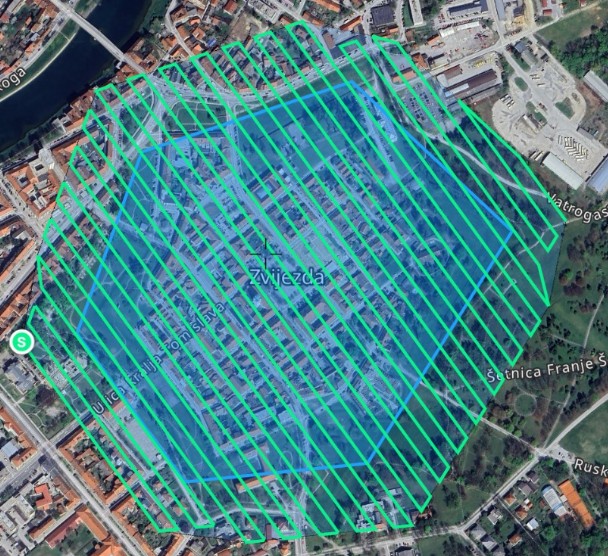
A set of easy-to-implement procedures is important to achieve accurate and reliable results in built heritage documentation. From the authors’ experience, careful planning of flight paths, altitude, and camera settings is crucial and must comply with the mission objectives. Pre-flight site inspection and pre-determined flight paths can be used to identify safer flights and to increase time efficiency. Today, UAVs are equipped with high-resolution cameras, but setting the optimal altitude and overlapping of imaging is important to get the desired data and to model it in 3D. Camera settings such as ISO, shutter speed, aperture, and white balance are important and can be automated by careful planning, avoiding unfavourable weather conditions, and utilising diverse camera extensions and filters. Conducting thorough checks of the UAV system, including batteries, propellers, and sensors, before each flight is essential for safety. The safety of people, property, and the UAV itself should be respected at all times. To have optimal post-processing, the establishment of protocols for data storage, labelling and backup can be beneficial. Figure 5 presents a predefined UAV flight path developed for a photogrammetric survey mission of the heritage-protected urban core of Karlovac, Croatia. The figure illustrates the planned trajectory required for the drone to capture complete visual coverage of the target area, ensuring sufficient image overlap and spatial accuracy for 3D model reconstruction. Parameters such as flight altitude, velocity, image capture frequency, and camera orientation are predefined within the mission plan to optimise data quality and minimise processing errors.
Photogrammetry
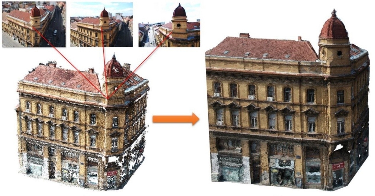
Photogrammetry is a technique used to create accurate 3D models from a collection of 2D images. UAVs equipped with high-resolution cameras capture a series of overlapping images from different angles, which are then processed using photogrammetry software. This software analyses the images, identifies common features, and calculates their position and depth, resulting in a detailed 3D model of the heritage structure. UAV photogrammetry has been widely used in heritage structures for the purpose of documentation of monuments (e.g. [106-107], damage detection (e.g. [102,108]), virtual tours of heritage sites (e.g. [109-110]), and even the creation of digital twins (DT).
The utilisation of UAVs has significantly enhanced the efficiency of both photogrammetry and DT techniques in heritage documentation. By utilising the capabilities of UAVs, these methodologies have become more streamlined, less time-consuming, and capable of capturing vast areas with ease. In the past, capturing data for a large heritage site could take weeks or even months, and with UAVs, it can be done within a matter of days or even hours. This data acquisition not only saves valuable resources but also minimises disruptions to the site and surrounding areas. Moreover, UAVs can access areas that are challenging to reach or pose safety risks to human operators, such as tall buildings, damaged premises, or remote locations [111-114]. In summary, the state-of-the-art in using UAVs for heritage documentation is extensive, with numerous case studies showcasing different approaches and methodologies (e.g. [115-117]).
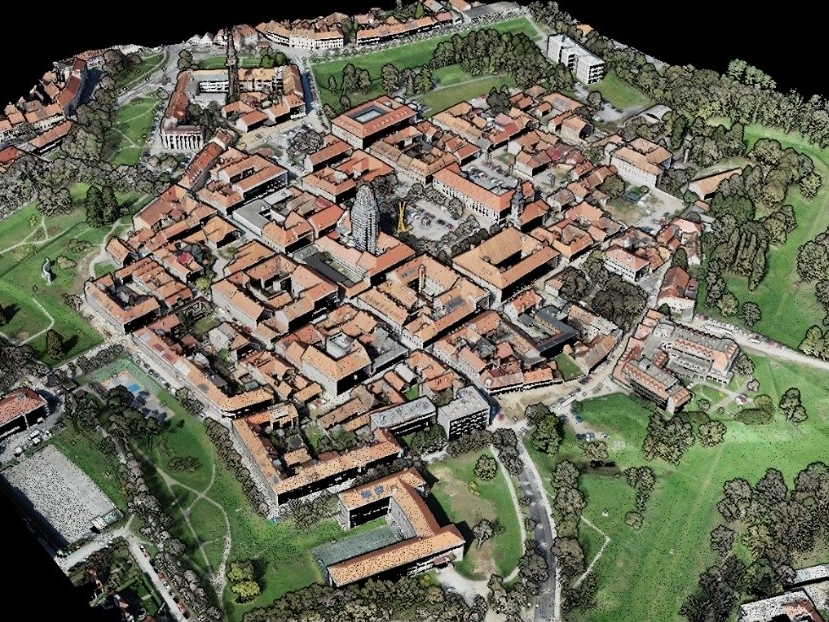
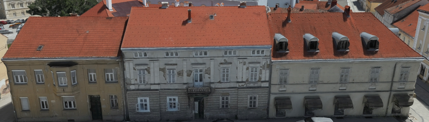
To show an example of the practical outcome of the predefined UAV mission presented in Figure 5, Figure 6 illustrates a comprehensive photogrammetric model of the urban core of Karlovac. The model demonstrates how systematic aerial data acquisition along a controlled flight path enables the generation of high-resolution, georeferenced 3D representations of complex urban areas. To provide a more detailed insight into the achievable level of precision, Figure 7 presents a close-up photogrammetric model of three representative buildings within the same survey zone. This detailed section highlights the model’s capacity to capture architectural geometry, façade textures, and surroundings with high spatial fidelity.
LiDAR systems
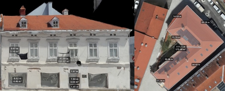
LiDAR (Light Detection and Ranging) is a remote sensing technique that uses lasers to measure distances and create highly accurate 3D point clouds. UAVs equipped with LiDAR sensors emit laser pulses toward the structure, and the reflected signals are captured to determine the distance and position of various points. The dense point clouds generated by LiDAR provide a representation of the geometry, shape, and topography of the site, enabling precise documentation and analysis. It is important to acknowledge that achieving precise documentation can come with high costs, as cutting-edge technologies and equipment often demand substantial investments. However, the use of LiDAR technology can be particularly attractive when dealing with extensive urban neighbourhoods or sizable architectural complexes and aggregate buildings [118], since the amount of data and process time is significantly less than using photogrammetry. The main benefits of the LiDAR system are non-destructive data capture, rapid data acquisition, and enhanced visualisation and analysis, such as volumetric measurements, surface deformation, or structural integrity assessment. Figures 8 and 9 show a comparison of data gathered by photogrammetry and LiDAR systems on UAVs, respectively, obtained by the authors. For the first building (Figure 8), a small commercial drone equipped with a 12MP camera (DJI Spark) was used. Flight time was approximately 30 minutes. The level of accuracy obtained was 2 mm. It must be noted that just the front façade and the roof were recorded. The objective of developing the model was to map damage and train it for automated building damage detection, specifically to distinguish and highlight the boundaries between damaged and undamaged areas of structures. Figure 9 shows one example of documenting the geometry of a bigger number of units in building blocks. The area was recorded by a LiDAR system mounted on the DJI Matrice 300 drone equipped with Zenmuse L1 [118]. Flight time was approximately 25 minutes, and the level of accuracy obtained was 5 cm. The mission aimed to obtain the geometrical features of buildings within an aggregate, including height, area, roofs and window characteristics, to facilitate seismic vulnerability analyses of individual buildings within that aggregate.
Using the LiDAR system in combination with the photogrammetric dataset, it becomes possible to accurately extract building dimensions, generate floor plans, and even identify openings on façades with minimal post-processing (Figure 10). The high spatial resolution of the acquired data enables precise geometric characterisation of both individual structures and their spatial relationships within the urban fabric. For this mission, the required level of precision was established at 1.6 cm/px, ensuring that the resulting point cloud provides sufficient accuracy for detailed structural assessment and for subsequent use in seismic vulnerability analyses.
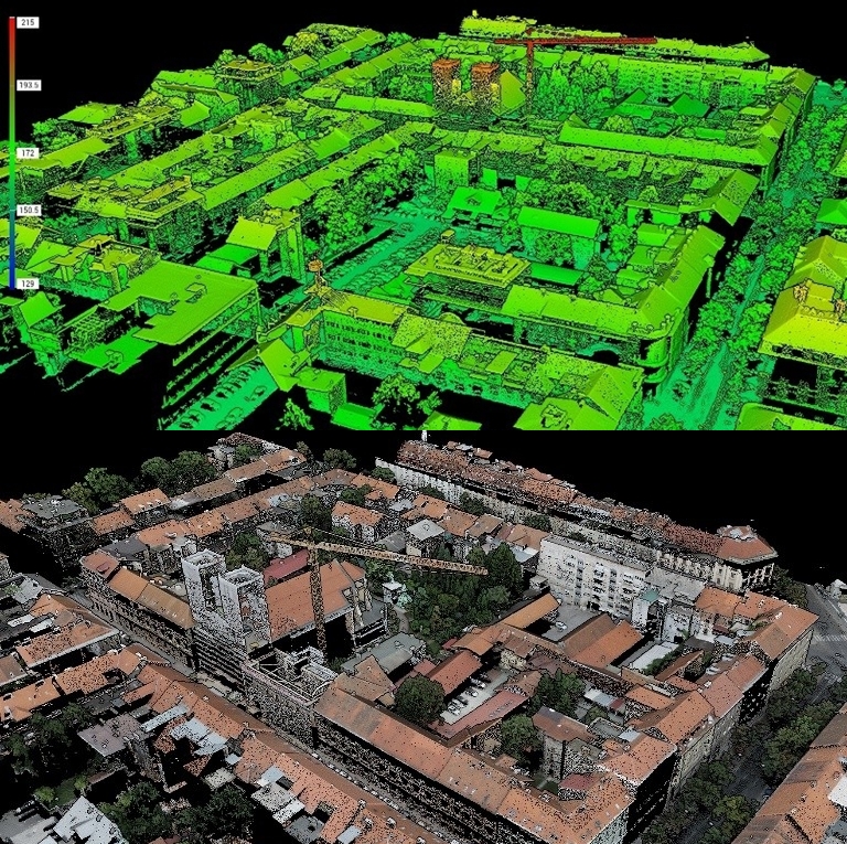
Another benefit of LiDAR is its capacity to penetrate vegetation and capture data on the complete structure, including architectural details that may be hidden by vegetation. Numerous authors exploring the potential of LiDAR systems mounted on UAVs [110,119-132] agree that the future of using LiDAR technology lies in combining the obtained data with other imagery to create comprehensive and multi-dimensional datasets for heritage documentation and analysis. Overall, LiDAR on UAV is an extremely fast data collection technique and can serve for long-term monitoring of heritage sites, enabling the detection and analysis of changes in structural integrity over time.
Thermal imaging
Thermal imaging is especially useful for identifying temperature variations and detecting anomalies such as heat leaks, moisture intrusion, insulation gaps, or structural deficiencies. As the main point of a thermal camera is energy efficiency analysis, thermal imaging data can be processed and visualised to create thermal maps or colour-coded images and can reveal areas of heat loss or energy inefficiencies in heritage buildings. Like all the other mentioned technologies, UAV-based thermal imaging enables non-destructive, rapid data acquisition. Present research in UAV-based thermal imaging lies in ways to achieve a more precise analysis and comparison of thermal patterns in heritage structures [133-135] by combining the data with other sensors’ data and the creation of multi-sensor fusion. Moreover, current research efforts include structural health monitoring applications of thermal imaging [136-138] and the development of algorithms for automated image processing [139] and anomaly detection [140-144].
Multispectral and hyperspectral imaging
Multispectral imaging involves capturing images across different spectral bands, beyond what the human eye can perceive. UAVs equipped with multispectral cameras can capture data in specific wavelengths to monitor structural integrity or assess material composition (i.e., such as stone, paint, vegetation, etc.). It can be used to detect and recognise vegetation and the density of vegetation around and on/at heritage buildings. The data (images) can reveal hidden patterns and features and can facilitate subsurface mapping. By comparing spectral signatures captured during different flights, it is possible to identify changes in material degradation or vegetation growth (e.g. [145]). As with other mentioned technologies, current research is oriented to combining the data with other sensors’ data and creation of multi-sensor fusion (e.g. [146]), data calibration and validation, structural health monitoring (e.g. [147]), and developing advanced algorithms for automation (e.g. [148]). As the field continues to evolve, the ongoing development of knowledge, coupled with data collection, holds great potential for conducting more comprehensive analyses of historical sites in the future (e.g. [149-150]).
Outcomes from international projects focused on using UAVs for heritage documentation
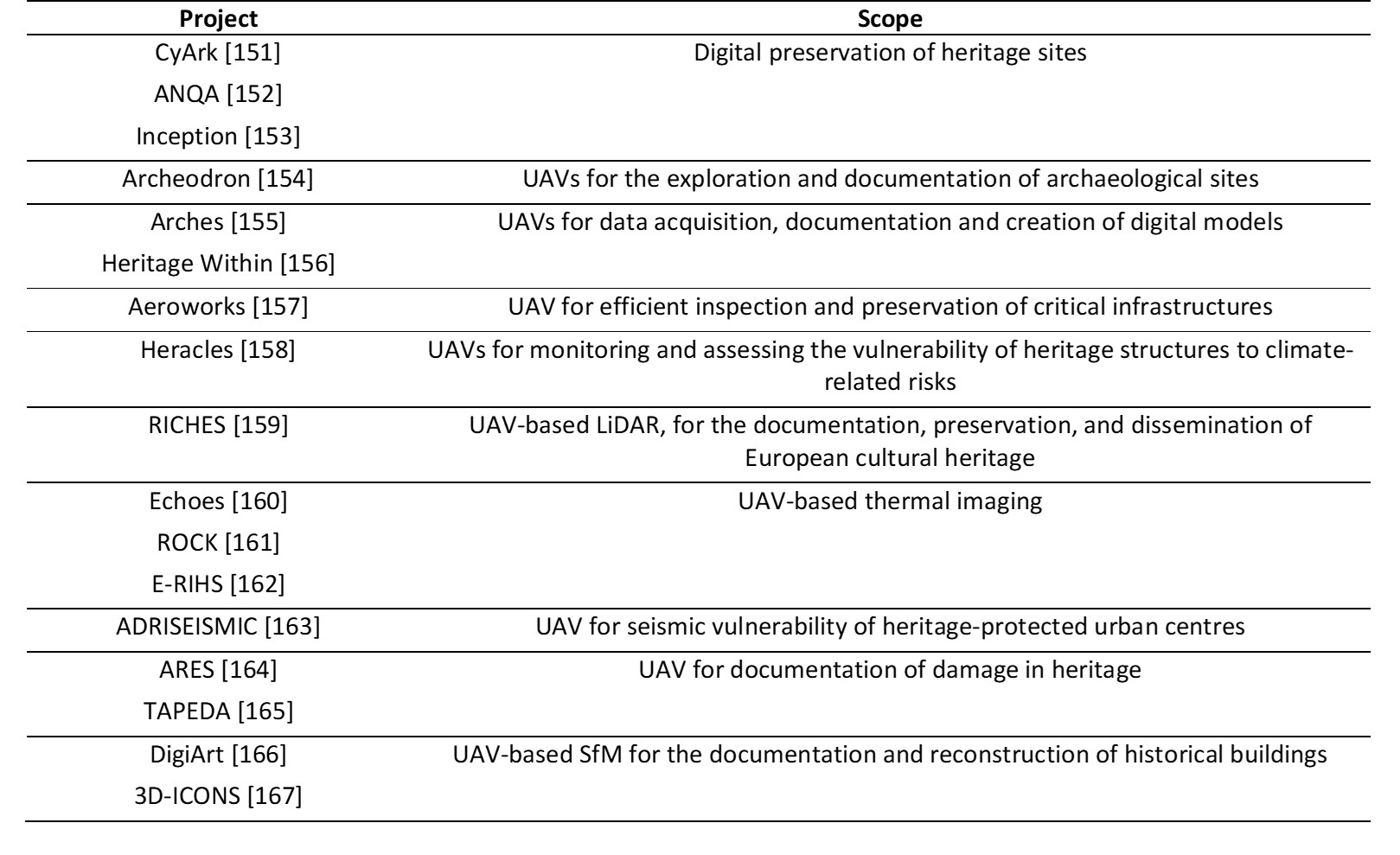
There have been several research projects focused on the use of UAVs for heritage. Table 1 shows a selection of projects and initiatives related to heritage documentation in Europe. In the following, we summarise some of the challenges encountered within the mentioned projects regarding the application of UAVs for heritage documentation, as identified in the reviewed studies.
Table 1. UAV and heritage documentation.
While UAVs offer significant advantages, several challenges need to be addressed. Very often, UAV operations are subject to strict regulations and airspace restrictions, even when all the flying permits are obtained. Additionally, the General Data Protection Regulation (GDPR) can arise as an issue. Harmonisation of regulations, flexibility, and effective enforcement mechanisms are necessary to address these challenges and foster a conducive environment for UAV-based heritage documentation. From a technical point of view, UAVs have payload limitations, restricting the type and number of sensors that can be carried. Identifying structural features and materials using UAVs in heritage sites requires high-precision sensors capable of capturing fine details and spectral signatures. The challenge lies in the accurate interpretation of these data to differentiate between various materials and detect subtle signs of degradation or alteration, which are crucial for the conservation of historic structures. UAVs face limitations in documenting the interior spaces of heritage buildings due to restricted access and GPS signal loss. Innovative solutions, such as indoor navigation systems or hybrid UAVs equipped with additional sensors, are required to overcome these obstacles and capture detailed interior data for comprehensive heritage documentation.
UAVs have emerged as powerful tools for the inspection and documentation of heritage structures. Their advantages, including enhanced safety, cost efficiency, and high-resolution data collection, make them invaluable assets in the field. While challenges and limitations exist, addressing them through improved regulations, technological advancements, and interdisciplinary collaborations will unlock even greater potential for UAVs in heritage documentation. By embracing technologies such as AI, and Augmented and Virtual Reality (AR/VR) applications, as well as advancements in sensors, the field will continue to evolve, ensuring the preservation and understanding of architectural heritage for generations to come.
Digital technologies for structural assessment of heritage structures
A data-driven decision-making process is key for the definition of a structural intervention strategy in a heritage structure based on the concept of minimum intervention [168]. Such a data-driven approach should be based on multi-level information coming from historical inspection, in-situ and laboratory testing, monitoring, and structural analysis. From this perspective, the digital twining paradigm fits very well within the scope of the study and protection of heritage structures.
In recent years, there has been an increased interest in the topic of digital twinning of heritage structures [169]. In the broad sense, a DT is a digital replica of a physical object that integrates data from sensors, simulations and analytics [170]. According to the application, the DT can facilitate one- or two-way (static or dynamic) exchange of information between physical and digital objects, providing the possibility for a reactive data-informed decision-making approach for the maintenance of existing structures. In most heritage structure applications, information still flows in one direction, with the digital object receiving and reflecting the physical object’s condition at a given point in time. Digital representations that mirror a physical asset’s current condition using sensor data are typically referred to in the literature as digital shadows [171]. A digital shadow is a static or periodically updated digital model of a physical asset derived from data such as point clouds, but it does not involve continuous interaction. In contrast, a DT involves a dynamic, bidirectional link between physical and digital systems, enabling real-time monitoring and simulation. In heritage applications, the majority of current approaches correspond to digital shadows; however, ongoing developments are progressively moving towards DT implementations.
Here, our focus lies on the use of digital technologies for developing computational structural analysis models representative of the current structural state. To achieve this, the digital structural model should include realistic information regarding geometry, material properties, and existing damage. In the following, we present an overview of the strategies used in the literature to consider such information when developing a structural analysis computational model of an existing heritage masonry structure. Digitalisation for documentation and management, such as the use of Building Information Modelling technologies, is outside the scope of this review, and interested readers on these technologies are referred to relevant reviews, such as [172-174].
Modelling existing geometry: from point cloud to structural analysis
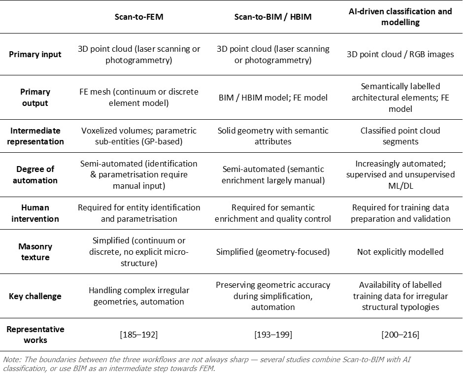
Geometry is among the most important parameters when assessing the structural stability of existing structures made from unreinforced masonry. This is due to the intrinsic mechanical characteristics of masonry, which exhibits much higher compressive strength than tensile strength. Due to this, and under the assumptions of the lower-bound (or safe) theorem [175], a structure can be evaluated as safe when a thrust line, in equilibrium with external loads, falls within its geometrical boundaries. Table 2 summarises the main workflows used to move from a point cloud to a structural analysis model, which are presented in the following.
Long before the concept of digital twinning was introduced, structural engineers were looking for ways to generate computational models that reflect as closely as possible the actual geometrical (deformed) state of the analysed structure. As already mentioned in Section 3, this can be achieved using geomatic technologies such as laser scanning and photogrammetry. 3D point clouds directly obtained from laser scanning (e.g. [176-180]) or after processing images through photogrammetry [177-178,181-184] have served for a long time as the basis for a manual definition of the surfaces and volumes of the investigated structures.
The high time cost of manual processing of point clouds motivated early research on semi- or fully automated pipelines for geometry generation. Linh Truong-Hong and Laefer [185] developed a pipeline for an octree-based boundary detection and model generation through voxelization of building facades scanned with LiDAR. Riveiro et al. [186] developed a fully automated procedure for segmenting 3D point clouds for masonry arched bridges for use in structural health monitoring. Castellazzi and co-workers [187-188] developed a semi-automated segmentation of 3D point clouds for the generation of finite [189] or discrete [190] element models of buildings. The pipeline is based on the generation of closed horizontal planar surfaces by sliding the 3D point cloud at different heights and then stacking and voxelizing those surfaces for the generation of a 3D volumetric finite/discrete element model, where each voxel corresponds to a finite/discrete element. An important feature of the approach is the possibility to generate 3D computational models of complex geometries. The result of these pipelines is a structural model with a simplified representation of the masonry texture, either as a continuum or as discrete, but without representing the actual masonry texture and micro-structure.
Angjeliu et al. [191] introduced the concept of generative programming (GP)-based modelling for the geometric representation of complex structural components (e.g., vaults, ribs), combined with manual CAE modelling for simpler geometries (e.g., piers, walls). Their semi-automated framework integrated geometric, material, and monitoring data within a hierarchically structured simulation model, aiming to establish continuous correspondence between the physical and numerical representations of historical masonry buildings. The methodology was applied to study the structural evolution of the Milan Cathedral (Italy). Funari et al.[192] proposed a generative programming (GP)-based Scan-to-FEM framework for creating calibrated finite element models from point clouds of historic masonry structures. The approach represents the geometry as an assemblage of parametrically defined entities composed of sub-entities (e.g., pillars, arches, walls, vaults). The procedure involves: i) the identification and parametrisation of the structural sub-entities, ii) the assembly of entities (e.g. nave, tower) from these sub-entities, iii) the assembly of the structure from the entities, and iv) the automated transfer of the geometry and the mechanical properties into a finite element environment via Python scripting. The workflow is semi-automated: the identification and parametrisation steps require manual intervention, while the generation, assembly, and FE import are largely automated. The methodology was validated through the complex case of the St. Torcato Church (Portugal), demonstrating that the GP approach enables consistent and computationally efficient model generation suitable for DT applications.
Table 2. Comparison of the main workflows for geometry-to-model generation in heritage masonry structures.
The growing use of Building Information Modelling (BIM) for the documentation and management of heritage masonry structures has motivated the development of workflows for transforming BIM models into finite element models. Early applications focused on integrating BIM into the process from point cloud acquisition to FE modelling [193-195]. Although these procedures successfully produced FE models of complex structures, they were labour-intensive and only partially automated. Leonardi et al. [196] advanced this research line by developing a fully open-source automated pipeline for generating FE models from BIM in Industry Foundation Classes (IFC) format. The workflow converts a BIM model into a solid tetrahedral FE mesh and assigns all necessary mechanical properties and boundary conditions automatically. The methodology was validated through the linear analysis of a case study on a complex masonry aggregate in Ortigia (Syracuse, Italy), where the automatically generated model produced results consistent with manually built FE models.
In parallel, the concept of Heritage Building Information Modelling (HBIM) has emerged as a framework for integrating heterogeneous geometric, material and historical data into a single digital model. Unlike conventional BIM systems, HBIM is specifically designed to represent the irregular geometry and complex construction systems of heritage buildings. It acts as a digital repository that links geometric reconstruction with structural assessment and conservation documentation. Recent developments have explored automating the semantic enrichment of these models directly from 3D point clouds [197,198]. Garcia-Gago et al. [199] propose integrating highly detailed 3D point clouds into BIM workflows. This is particularly valuable during the diagnostic phase, as it preserves geometric accuracy often lost when converting point clouds into simplified 3D models.
Studies such as that of Cotella et al. [200] highlight that the Scan-to-BIM process for historic constructions remains largely semi-automatic. Although several recent approaches already integrate AI, such as LLMs [201,202], to automatically recognise and classify structural components—such as walls, vaults, columns, and roofs—from 3D point clouds, the overall workflow still requires significant human intervention. ML and DL algorithms [203,204] leverage the geometric [205] and radiometric [206,207] data embedded in point clouds to accurately distinguish architectural elements. Supervised ML approaches [208-210], unsupervised clustering techniques [206,207,211], and more advanced DL approaches [212,213] have demonstrated their effectiveness in semantically classifying architectural typologies and construction systems. These advances are a significant step towards fully automated Scan-to-BIM workflows and could be instrumental in the automatic development of computational models for the structural analysis of heritage structures.
Pantoja-Rosero and co-workers [214,215] developed a fully automated image-based end-to-end pipeline for the generation of finite element meshes for equivalent frame and continuum-based models of the outer walls of masonry buildings, given their thickness. The pipeline is based on computer vision and is the first to use DL technologies for identifying wall and roof surfaces and openings corresponding to door and window openings. The same methodology was used later in Ariss et al. [216] for the nonlinear analysis of unreinforced masonry building facades under in-plane loading.
Computational modelling of the masonry typology
The workflows for generating computational models discussed above represent masonry as either a continuum or a discontinuum medium, without explicitly accounting for the geometric characteristics of the stone masonry typology. However, experimental studies [217-221] have shown that the mechanical properties of masonry depend on both the properties of the units and the mortar, as well as the arrangement of the units within the wall, i.e. the masonry typology. The high costs and time invested in experimental testing, coupled with the large variability of masonry typologies and the inherent uncertainty in materials, have underscored the need for numerical studies [222-223]. These could complement and extend experimental investigations in understanding the structural role of specific masonry typologies.
Accurate numerical simulations require a detailed mesh that represents the shape and arrangement of masonry units in the wall. The first step towards achieving this is the development of a stone masonry typology generator that can be used to generate diverse masonry typologies. Over time, various masonry typologies generation methods have developed to generate 2D/3D meshes for numerical simulations. First endeavours involved manually segmenting mortar and stone units in 2D images to create input meshes for numerical models [224-226]. This process has been improved by automating segmentation using computer vision and deep learning techniques [227-230]. Some other studies have extracted 2D micro-geometry from RGB images for health monitoring of existing structures [231-232]. Castori [233] created a 3D FE mesh from RGB images using digital image processing algorithms, while Abu-Haifa and Lee [234] developed an image-based modelling-to-simulation pipeline for 3D discrete element modelling of masonry structures.
Most recent advancements include the development of virtual stone and brick masonry generators. Zhang et al. [235] developed a 2D microstructure generator based on computer vision, inspired by the work of Miyata [236], which was later used to generate different masonry typologies to investigate the influence of masonry typology on the shear response of walls through discrete finite element modelling [222]. Vadalà et al. generated single-leaf masonry typologies based on rectangular-shaped units using a Grasshopper-based geometrical algorithm [237]. Shaqfa and Beyer [238] developed a 3D microstructure generator that can prepare detailed meshes of single- or multi-leaf stone/brick masonry walls based on a multi-objective optimisation packing approach. Szabó et al. [239] introduced a microstructure generator for rectangular course masonry, which creates various masonry patterns based on the masonry quality index and arrangement. Kamel and Massart [240] proposed an automated methodology to extract mortar joint descriptions from irregular masonry geometries, enabling the direct generation of cohesive zone FEM models for mechanical simulations.
More recently, Wang et al. [241] presented an image-based method for automating the stacking of non-uniform stones in the construction of 2D load-resistant stone masonry walls. The authors tested the load-carrying capacity of the developed walls using a variational rigid-block modelling approach, demonstrating the capacity of the algorithm to develop realistic load-bearing walls in an efficient way. In a follow-up study, Wang et al. [242,243] also developed a unified stone stacking algorithm that deals with the geometric planning of multi-leaf masonry walls with regular and irregular stone shapes. This algorithm overcomes the limitations of existing stone stacking algorithms [238,244-245], which struggle to incorporate the traditional rules of art used by masons.
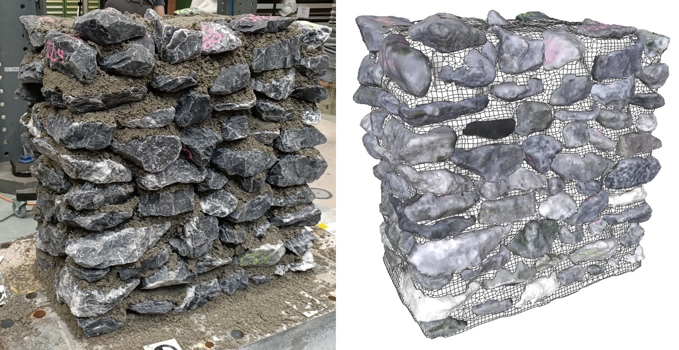
In parallel, there has been significant progress in generating realistic numerical models of existing walls. Tiberti and Milani [246] generated 2D finite element meshes of existing stone masonry typologies from images. An image of the wall is first transformed to a rasterised black-and-white or grey-scale image, and each pixel is assigned to a mortar or stone unit based on the red value of its RGB triplet. The final finite element mesh is then developed by transforming each pixel into a rectangular finite element. The same approach was then used for the development of (hypothetical) 3D geometries from images of existing walls, by extruding the stones through the wall thickness [247]. The method allows both simple transversal extrusion and ellipsoidal extrusion of the stone units through the wall thickness for single-leaf walls. In a follow-up study [248], authors further extended their method to generate the 3D geometry for multi-leaf walls. Pereira et al. [249] developed a pipeline for the automatic generation of multi-leaf non-periodic block-by-block patterns that considers, in a probabilistic way, the distribution and size of units at the wall surface. The algorithm produces single or two-leaf walls by extruding the stone face through the wall thickness. In the same work, the algorithm was used to analyse an existing heritage stone masonry structure through block-based limit analysis and block-based finite element models. Wang et al. [250] introduced an automated technique for generating synthetic 3D models of rubble-stone masonry walls from images of real walls, ensuring that generated walls statistically resemble the geometric features and construction characteristics of the source wall. Several other techniques have been developed to generate 3D masonry texture based on point cloud data and images, but these methods cannot capture internal masonry morphology [211,250-252]. The above approaches aim to develop realistic irregular masonry typologies through images, or a set of geometrical rules reinforced in some cases by case-dependent statistical data [219]. However, they are not yet capable of accurately representing irregular masonry typologies of existing masonry structures. Until today, this has been possible only for specimens constructed in a laboratory, where photogrammetry [54] and laser scanner-based pipelines [253] have allowed the generation of a geometrical DT at the level of unit of newly built masonry walls (Figure 11). Ullah-Shah et al. [254-255] have curated and made openly available a database including these geometrical DTs of experimentally tested stone masonry walls, along with wall microstructures created through virtual masonry generators. While these works pave the road for the generation of detailed finite element models of stone masonry walls that will allow an accurate estimation of their structural response, they do not provide a solution for the generation of geometrical DTs of existing masonry typologies in heritage structures. A possible way to obtain information about the internal masonry morphology so that it can be represented in a numerical model is by using non-destructive techniques such as radar or acoustic methods. As described earlier, while important steps have been made for the tomographic representation of wall sections of existing masonry walls, the current level of detail in those tomographic representations does not permit the generation of a geometrical DT of the existing masonry texture.
When it comes to regular masonry typologies, such as brick masonry, the regularity of unit dimensions and repetitiveness of the masonry pattern reduce the complexity, making the digital twinning of existing structures possible. Along this line, Loverdos and Sarhosis [256] presented a pipeline for the generation of digital twins of brick masonry structure cracks based on computer vision and machine learning. Convolutional neural networks were trained to identify the blocks and cracks in an image of an existing structure and differentiate those from the background. Extracted features (i.e., bricks and cracks) are then transformed into polylines and exported in a CAD-based environment. The output is a planar geometrical DT of the wall face with existing cracks that can be used for the development of numerical models. Still, the generalisation of this pipeline for the generation of 3D computational models needs some information on the geometrical variation of brick masonry through the wall thickness. Along the same line, Griesbach et al. [257] proposed an AI-assisted, semi-to-fully automated workflow that transforms image-based data into three-dimensional discrete block models of unreinforced masonry walls. The pipeline combines machine learning-based segmentation—for detecting masonry units from orthoimages of the structure—with engineering-informed statistical reconstruction of occluded wall regions. The reconstruction of the latter hidden or inaccessible areas is based on statistical parameters extracted from visible regions, specifically the block length distribution and the horizontal staggering of head joints. The method significantly reduces the modelling effort required for discontinuum analyses, although it is currently limited to regular, single-leaf masonry walls.
Computational modelling of existing damage
Historic damage and deformation of existing structures are sources of important information about past actions and structural performance, as well as indications for a local alteration of the material mechanical properties. The latter is particularly important when assessing the actual structural capacity and performance of an existing damaged structure. While modelling existing deformation can be considered as an integral part of the modelling approaches discussed above, the incorporation of damage in an existing model is not merely a geometrical problem. To consider the influence of existing damage in the structural response, the structural analysis model should include both the topological information of the damaged zone (i.e., a geometrical definition of damage) and the local change in the mechanical properties.
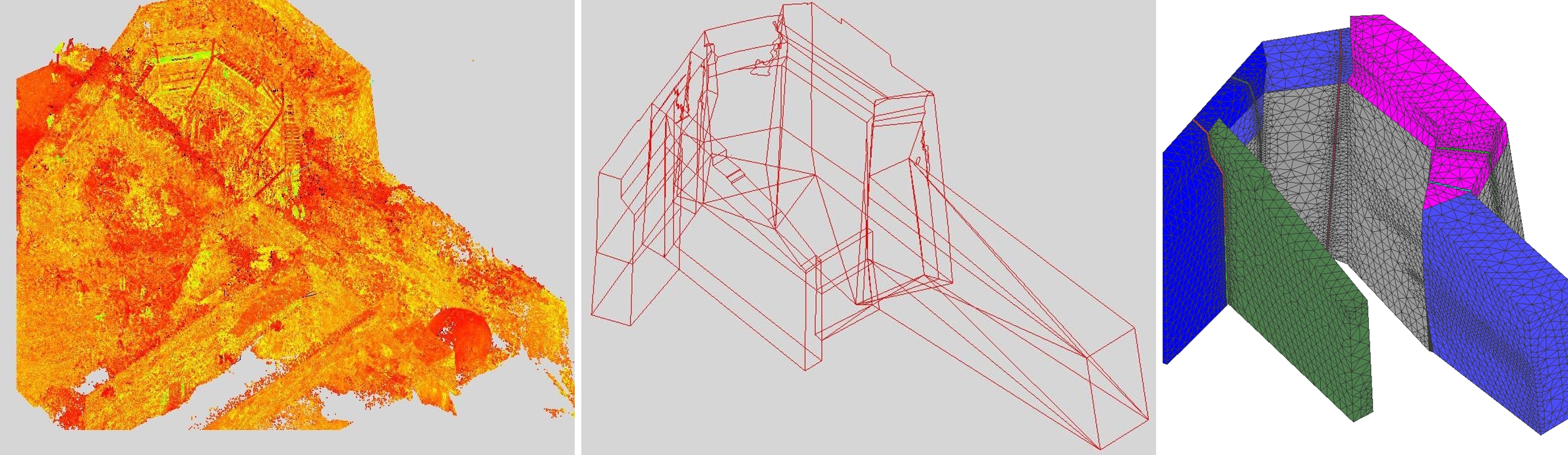
Current research practice uses information from laser scanning or photogrammetry to identify the location of damage, which is then manually defined in the computational model (e.g. [183,258]), see Figure 12. In recent years, there has been an increased interest in leveraging the power of Artificial Intelligence for the identification of damage in existing structures from images [214,256,259] and 3D point clouds [207,260]. To date, there is a notable lack of standardisation in the algorithms utilised for both segmentation and damage analysis in heritage conservation. This variability frequently complicates the integration of AI technologies into broader diagnostic workflows [260]. To address this challenge, Sánchez-Aparicio and co-workers developed the open-source software Seg4D [261], which consolidates several AI-based segmentation and diagnostic tools into a unified framework. This framework, extracted from the Sánchez-Aparicio et al. review [262], is based on the proposal of a novel classification system for damage detection based on 3D point clouds. The dual focus of Seg4D on both segmentation and damage detection provides a comprehensive approach to addressing the diagnostic needs of historic buildings. By unifying multiple ML and DL algorithms, the platform facilitates the consistent identification of construction systems and automates structural damage detection, such as arch and vault deformation, wall inclination and slab deflection. This effort towards standardisation through open-source tools represents a crucial step in the development of reliable and automated diagnostic processes in the field of heritage conservation.
Until now, the above works have focused on the automatic identification and mapping of existing cracks on a geometrical representation of the structure, without, however, providing a correlation between cracking and degradation of mechanical or structural properties. Such a correlation has been recently investigated for experimentally tested stone masonry walls by Rezaie and co-workers [263], who used machine-learning algorithms to correlate the crack characteristics (i.e., maximum crack-width, crack length and complexity dimension) with degradation of strength and stiffness, as well as displacement capacity of the walls. Pereira et al. [264] have applied a similar approach for finding a correlation between crack patterns and residual drift capacity of damaged masonry walls, but based on numerically generating damaged wall scenarios. The generalisation of the results of these studies to different masonry typologies could benefit the generation of equivalent frame models (EFM) of existing damaged structures.
Modelling of damage in a continuum finite element model is commonly performed through reverse engineering by using the results of operational modal analysis [265]. Operational modal analysis aims to identify the most significant modal frequencies and shapes of the structure through dynamic identification tests. Based on these results, the numerical model can be calibrated by adopting linear elastic properties in the damaged zones and reducing the elastic properties of the damaged materials, or by introducing material discontinuities corresponding to cracked zones. This iterative method aims to minimise an objective function, which compares one or more numerical and experimental dynamic characteristics, such as modal frequencies and modal shapes [265]. The model updating can either be done in a “discrete” way by changing the mechanical properties in narrow bands, representing damage localisation zones (e.g., [183,258,265-266]) or in a “smeared” way by changing the mechanical properties in larger material volumes, representing average properties of a damaged zone (e.g., [267-271]). Apart from modelling damage, calibration of numerical models based on operational modal analysis data can allow for a better estimation of the boundary conditions with adjacent structures.
As described, the model calibration procedure based on operational modal analysis is an iterative approach, which can be time-consuming, especially for large structures. Moreover, there is no guarantee of the uniqueness of a solution to the minimisation problem, as there could be more than one combination of material and damage characteristics that can lead to the minimisation of the objective function for a given error. Nevertheless, as demonstrated by the works discussed in this section, this calibration process enhances the digital representation of the physical object by reducing the uncertainty with respect to numerical modelling of key dynamic properties, such as modal shapes and eigenfrequencies, even under ambient vibrations. The calibrated damage-enhanced model can serve as a good starting point for evaluating the structural safety and the effect of possible interventions, given the condition that nonlinear phenomena can be simulated.
Conclusions
This article has presented a wide range of applications of automation systems and digital technologies in the field of inspection and conservation of the built heritage. Even though most of the state-of-the-art applications are computer-vision and LiDAR-based inspections that provide information related to the visible surfaces of the architectural assets, current research also focuses on the use of automated terrestrial systems and UAVs for non-destructive inspections that can provide information about the interior of an existing structure, such as the internal microstructure and characteristics like material properties. Similarly, digital environments and technology are still mostly used for the 3D graphical reconstruction of the surfaces of an object, as well as to store information obtained from the structure after an inspection, such as damage or NDT data. However, recent works are increasingly focusing on adding information beyond the visible surface, such as the wall microstructure, to the digital models of existing masonry structures.
The developments related to the inspection of the masonry structures play an important role in the generation of computational tools for structural analysis that represent the current state of an existing masonry structure. Geomatic approaches based on laser-scanning and photogrammetry are the backbone for the geometry acquisition of existing structures. The use of machine learning techniques has made it possible to identify and include information in the computational models related to the presence and location of damage. Existing damage is considered in the numerical analysis either in a “smeared way” or in a “discrete way” by adapting the material parameters of large zones or locally at the location of damage, respectively. In both cases, operational modal analysis is the most common method to obtain experimental information for calibrating the material parameters in numerical models.
Numerical models of large-scale masonry structures are usually based on a macro-modelling approach, considering the influence of the masonry typology through homogenization approaches. In recent years, there have been significant steps towards the development of numerical models that can explicitly consider the influence of the masonry typology, with existing applications focusing on a fictitious (but realistic) masonry typology generation or a statistically representative sample of an existing structure. More recently, the advancement in typology generators developed based on image technology, engineering-informed statistical information, and geometrical planning algorithms has enabled the generation of 3D microstructures. However, for existing structures, the geometrical digital twinning at the level of the component remains constrained by the limited accessibility of the internal morphological information on the multi-leaf masonry typology through the wall thickness. While non-destructive testing and data-driven approaches provide valuable insights, accurately resolving the true internal morphology of irregular multi-leaf masonry walls remains challenging. Nevertheless, the mentioned advances in the field pave the road for the generation of detailed finite element models of existing heritage structure walls that will allow an accurate estimation of their structural response and therefore a more efficient and effective conservation strategy.
The review has thus shown two clear gaps of knowledge in the field that could be addressed: (i) 3D reconstruction of a heritage asset is, in most cases, lacking the representation of the internal morphology of its structural elements, e.g., shape and size of stones and their position within a masonry wall. Non-destructive techniques coupled with machine learning algorithms can help to this purpose, but still lack validation for diverse irregular masonry typologies. (ii) Computational models of existing structures are static ones and aim to represent the status of the structure at the moment of inspection. The accuracy of these models to represent the real structure can be enhanced with the fusion of multi-modal data from sensors placed in the structure that capture real-time operational data. The association between physical objects and virtual ones makes it possible to activate data analysis and monitoring of the monuments in such a way that it is possible to operate in predictive mode, identifying problems even before they occur. The combination of the different approaches explored in the present document can be essential to fill these gaps in knowledge and achieve a more efficient structural diagnosis of the asset.
Author Contributions
Javier Ortega: Conceptualisation, Investigation, Data Curation, Writing – original draft, Writing – review & editing, Funding Acquisition. Savvas Saloustros: Conceptualisation, Investigation, Data Curation, Writing – original draft, Writing – review & editing. Mislav Stepinac: Conceptualisation, Investigation, Data Curation, Writing – original draft, Writing – review & editing. Pablo Sanz-Honrado: Conceptualisation, Investigation, Data Curation, Writing – original draft, Writing – review & editing. Fernando Ramonet: Conceptualisation, Investigation, Data Curation, Writing – original draft, Writing – review & editing. Mati Ullah Shah: Conceptualisation, Investigation, Data Curation, Writing – original draft, Writing – review & editing. Katrin Beyer: Conceptualisation, Writing – review & editing, Supervision. Sofia Aparicio: Conceptualisation, Investigation, Data Curation, Writing – original draft, Writing – review & editing, Supervision, Funding Acquisition, Project administration. All authors have read and agreed to the published version of the manuscript.
Conflicts of Interest and Transparency Statement
The authors declare no conflict of interest. The authors declare that they have no known competing financial interests or personal relationships that could have appeared to influence the work reported in this article. This article was authored by the Editor-in-Chief and Associate Editor of the journal. To ensure strict academic integrity and a completely unbiased evaluation, the author was completely recused from the editorial, peer-review, and decision-making workflows for this manuscript. The entire review process and final acceptance decision were managed independently and exclusively by the second Associate Editor. The manuscript underwent the journal’s standard double-blind peer-review process by independent external reviewers.
Funding
This project has received funding from the I-LINK project ‘Robotics and automation for NDT Inspection of Heritage Structures’, ref. iLINK22031, from CSIC. The project is also supported by a fellowship from the Fundación General CSIC´s ComFuturo programme, which has received funding from the European Union’s Horizon 2020 research and innovation programme under the Marie Skłodowska-Curie grant agreement No. 101034263. The article is also part of the project PID2022-140071OB-C21, funded by MCIN/AEI/10.13039/501100011033/FEDER, UE. Pablo Sanz’s pre-doctoral contract is part of the grant PID2022-140071OB-C21, funded by MCIN/AEI/10.13039/501100011033 and ESF+.
Data Availability Statement
The supporting data is available on request from the corresponding author.
Acknowledgments
The authors gratefully acknowledge the support of the collaborating institutions involved in this work.
References
[25] Masini N, Persico R, Rizzo E. Some examples of GPR prospecting for monitoring of the monumental heritage. J Geophys Eng. 2010;7(2):190-199. https://doi.org/10.1088/1742-2132/7/2/S05[26] Ramos LF, Nuñez AC, Fernandes FM, Lourenço PB. Evaluation of Structural Intervention in the Quartel das Esquadras, Almeida (Portugal). Int J Archit Herit. 2018;12(3):465-485. https://doi.org/10.1080/15583058.2017.1323975[27] Watanabe A, Even J, Morales LY, Ishi C. Robot-assisted acoustic inspection of infrastructures – Cooperative hammer sounding inspection. In: Proceedings of 2015 IEEE/RSJ International Conference on Intelligent Robots and Systems (IROS); 2015 Sep 28 – Oct 2; Hamburg, Germany. IEEE; 2015. p. 4930-4935. https://doi.org/10.1109/IROS.2015.7354222[28] Li B, Ushiroda K, Yang L, Song Q, Xiao J. Wall-climbing robot for non-destructive evaluation using impact-echo and metric learning SVM. Int J Intell Robot Appl. 2017;1:255-270. https://doi.org/10.1007/s41315-017-0028-4[29] Feng J, Xiao H, Hoxha E, Song Y, Yang L, Xiao J. Automatic Impact-sounding Acoustic Inspection of Concrete Structure. In: Cunha A, Caetano E, editors. Proceedings of 10th International Conference on Structural Health Monitoring of Intelligent Infrastructure (SHMII 10); 2021 Jun 30 – Jul 2; Porto, Portugal. 2021. arXiv:2110.13125[30] Hoxha E, Feng J, Sanakov D, Gjinofci A, Xiao J. Robotic Inspection and Characterization of Subsurface Defects on Concrete Structures Using Impact Sounding. In: Proceedings of 13th International Workshop on Structural Health Monitoring; 2022; Stanford, USA. 2022. arXiv:2208.06305[31] Xie L, Huang Q, Zhao Y, Yin G. Inspection of magnetic tile internal cracks based on impact acoustics. Nondestruct Test Eval. 2015;30(2):147-164. https://doi.org/10.1080/10589759.2015.1018255[32] Caliano G, Mariani F, Calicchia P. PICUS: A Pocket-Sized System for Simple and Fast Non-Destructive Evaluation of the Detachments in Ancient Artifacts. Appl Sci. 2021;11(8):3382. https://doi.org/10.3390/app11083382[33] Nassif HH, Gindy M, Davis J. Comparison of laser Doppler vibrometer with contact sensors for monitoring bridge deflection and vibration. NDT E Int. 2005;38(3):213-218. https://doi.org/10.1016/j.ndteint.2004.06.012[34] Garg P, Nasimi R, Ozdagli A, Zhang S, Mascarenas DD, Taha MR, et al. Measuring Transverse Displacements Using Unmanned Aerial Systems Laser Doppler Vibrometer (UAS-LDV): Development and Field Validation. Sensors. 2020;20(21):6051. https://doi.org/10.3390/s20216051[35] Wenzel H. Structural assessment of the cultural heritage. IABSE Congr Rep. 2000;16(10):1105-1112.[36] Pieraccini M, Fratini M, Dei D, Atzeni C. Structural testing of Historical Heritage Site Towers by microwave remote sensing. J Cult Herit. 2009;10(2):174-182. https://doi.org/10.1016/j.culher.2008.09.006[37] Diaferio M, Foti D, Gentile C, Giannoccaro NI, Saisi A. Non-destructive experimental tests on a historical slender structure. In: Proceedings of the 6th International Operational Modal Analysis Conference (IOMAC 2015); 2015 May 12-14; Gijón, Spain. 2015.[38] Livitsanos G, Saisi A, Aggelis DG, Gentile C. Radar Interferometer Application for Remote Deflection Measurements of a Slender Masonry Chimney. In: Moropoulou A, et al., editors. Transdisciplinary Multispectral Modeling and Cooperation for the Preservation of Cultural Heritage. CCIS 962. Cham: Springer; 2019. p. 430-442.[39] Pallarés FJ, Betti M, Bartoli G, Pallarés L. Structural health monitoring (SHM) and Nondestructive testing (NDT) of slender masonry structures: A practical review. Constr Build Mater. 2021;297:123768. https://doi.org/10.1016/j.conbuildmat.2021.123768[40] Castellini P, Esposito E, Marchetti B, Paone N, Tomasini EP. New applications of Scanning Laser Doppler Vibrometry (SLDV) to non-destructive diagnostics of artworks: mosaics, ceramics, inlaid wood and easel painting. J Cult Herit. 2003;4(1):321-329. https://doi.org/10.1016/S1296-2074(02)01148-2[41] Lynch JP, Sundararajan A, Law KH, Kiremidjian AS, Carryer E, Sohn H, et al. Field validation of a wireless structural monitoring system on the Alamosa Canyon Bridge. In: Proceedings of SPIE: Smart Structures and Materials 2003: Smart Systems and Nondestructive Evaluation for Civil Infrastructures. Vol. 5057. Bellingham: SPIE; 2003. p. 267-278.[42] Krueger M, Grosse CU, Reinhardt HW. Structural health monitoring with wireless sensors to enhance sustainability in structural engineering. In: Proceedings of IABSE Symposium: Improving Infrastructure Worldwide; 2007 Sep 19-21; Weimar, Germany. Zurich: IABSE; 2007. p. 202-203.[43] Martínez-Garrido MI, Aparicio S, Fort R, Anaya JJ, Izquierdo MA. Effect of solar radiation and humidity on the inner core of walls in historic buildings. Constr Build Mater. 2014;51:383-394. https://doi.org/10.1016/j.conbuildmat.2013.10.068[44] Zonta D, Wu H, Pozzi M, Zanon P, Ceriotti M, Mottola L, et al. Wireless sensor networks for permanent health monitoring of historic buildings. Smart Struct Syst. 2010;6(5):595-618.[45] Barsocchi P, Cassara P, Mavilia F, Pellegrini D. Sensing a city’s state of health: Structural monitoring system by internet-of-things wireless sensing devices. IEEE Consum Electron Mag. 2018;7(2):22-31. https://doi.org/10.1109/MCE.2017.2717198[46] Mesquita E, Arêde A, Pinto N, Antunes P, Varum H. Long-term monitoring of a damaged historic structure using a wireless sensor network. Eng Struct. 2018;161:108-117. https://doi.org/10.1016/j.engstruct.2018.02.013[47] Barsocchi P, Bartoli G, Betti M, Girardi M, Mammolito S, Pellegrini D, et al. Wireless sensor networks for continuous structural health monitoring of historic masonry towers. Int J Archit Herit. 2021;15(1):22-44. https://doi.org/10.1080/15583058.2020.1719229[48] Aparicio S, Martínez-Garrido MI, Ranz J, Fort R, Izquierdo MA. Routing Topologies of Wireless Sensor Networks for Health Monitoring of a Cultural Heritage Site. Sensors. 2016;16(10):1732. https://doi.org/10.3390/s16101732[49] Aparicio S, Anaya JJ, González M, García MA, Martínez-Garrido I, Fort R. Monitoring data of internal temperature and humidity measurements of the walls of the Church of Talamanca del Jarama at different heights [Dataset]. DIGITAL.CSIC; 2023. https://doi.org/10.20350/digitalCSIC/15111[50] Pavlidis G, Koutsoudis S, et al. Future-Proofing Heritage with ARGUS: A Multimodal Digital Twin Approach for Sustainable Preservation. In: Proceedings of 52nd International Conference on Computer Applications and Quantitative Methods in Archaeology (CAA); 2025 May 5-9; Athens, Greece. 2025.[51] Ramonet F, Abad L, González M, Anaya JJ, Lluch A, Sanz-Honrado P, et al. Sensor-Driven Preventive Preservation of Underground Heritage: A Case Study of the Wine Cellars of Baltanás. Heritage. 2026;9(3):91. https://doi.org/10.3390/heritage9030091[52] Mekki K, Bajic E, Chaxel F, Meyer F. A comparative study of LPWAN technologies for large-scale IoT deployment. ICT Express. 2019;5(1):1-7. https://doi.org/10.1016/j.icte.2017.12.005[53] Aparicio S, Liébana JC, Anaya G, Martín R, Ortega J, García MA, et al. An Ultrasonic Tomography System for the Inspection of Columns in Architectural Heritage. Sensors. 2022;22(17):6646. https://doi.org/10.3390/s22176646[54] Ortega J, Meersman MF, Aparicio S, Liébana JC, Martín R, Anaya JJ, et al. An automated sonic tomography system for the inspection of historical masonry walls. Open Res Europe. 2023;3:60. https://doi.org/10.12688/openreseurope.15769.1[55] Ortega J, Meersman MF, Aparicio S, Liébana JC, Anaya JJ, González M. Influence of stress level and damage on sonic tomography imaging and on the estimation of deformability properties of historic stone masonry. Constr Build Mater. 2024;417:135285. https://doi.org/10.1016/j.conbuildmat.2024.135285[56] Słoński M, Schabowicz K, Krawczyk E. Detection of Flaws in Concrete Using Ultrasonic Tomography and Convolutional Neural Networks. Materials. 2020;13(7):1557. https://doi.org/10.3390/ma13071557[57] Jeon D, Kim MK, Jeong Y, Oh JE, Moon J, Kim DJ, et al. High-accuracy rebar position detection using deep learning–based frequency-difference electrical resistance tomography. Autom Constr. 2022;135:104116. https://doi.org/10.1016/j.autcon.2021.104116[58] Cantero-Chinchilla S, Wilcox PD, Croxford AJ. Deep learning in automated ultrasonic NDE – Developments, axioms and opportunities. NDT E Int. 2022;131:102703. https://doi.org/10.1016/j.ndteint.2022.102703[59] Araya-Polo M, Jennings J, Adler A, Dahlke T. Deep-learning tomography. Leading Edge. 2018;37(1):58-66. https://doi.org/10.1190/tle37010058.1[60] Muller AP, Bom IC, Costa JC, Klatt M, Faria EL, de Albuquerque MP, et al. Deep-Tomography: iterative velocity model building with deep learning. Geophys J Int. 2023;232(2):975-989. https://doi.org/10.1093/gji/ggac374[61] Ortega J, Aparicio S, González M, Anaya JJ. Aplicación de redes neuronales para generación de imágenes tomográficas de muros de mampostería. In: Actas del 15º Congreso Nacional de Ensayos No Destructivos (END); 2024 Jun 19-21; Valladolid. Madrid: AEND; 2024.[62] Hoxha E, Feng J, Sanakov D, Xiao J. Robotic Inspection and Subsurface Defect Mapping Using Impact-Echo and Ground Penetrating Radar. IEEE Robotics Autom Lett. 2023;8(8):4943-4950. https://doi.org/10.1109/LRA.2023.3290386[63] Xiao J, Hoxha E, Kirakosian D. Final Report – A Field Deployable Wall-Climbing Robot for Bridge Inspection using Vision and Impact Sounding Techniques [Internet]. Rolla: INSPIRE University Transportation Center; 2024 [cited 2026 May 13]. Report No.: INSPIRE-018. Available from: mst.edu[64] Nishimura Y, Mochiyama H, Yamaguchi T. Propeller-type wall-climbing robot for visual and hammering inspection of concrete surfaces. IEEE Access. 2024;12:70963-70972. https://doi.org/10.1109/ACCESS.2024.3402218[65] Zhang JY, Huang L, Guan YJ. Real-time defect detection in concrete structures using attention-based deep learning and GPR imaging. Sci Rep. 2025;15(1):35507. https://doi.org/10.1038/s41598-025-19596-1[66] Gallegos Garrido G, Sattar TP. An Autonomous Wall-Climbing Robot for Inspection of Reinforced Concrete Structures: SIRCAUR. J Artif Intell Technol. 2021;1(3):188-196. https://doi.org/10.37965/jait.2021.0016 [67] Božić M, Ćaran B, Švaco M, Jerbić B, Serdar M. Mobile Wall-Climbing Robot for NDT inspection of vertical concrete structures. In: Proceedings of the International Symposium on Nondestructive Testing in Civil Engineering (NDT-CE 2022); 2022 Aug 16-18; Zurich. https://doi.org/10.58286/27295[68] Anggara DW, Mohd Rahim MS, Zulkifli R, Husain AR, Mazni M, Ibrahim IS, et al. Concrete Crack Detection, Orientation and Measurement Using a Wall Climbing Robot [Internet]. Appl Model Simul. 2024 [cited 2026 May 13];8:272-282. Available from: arqiipubl.com[69] Yang L, Li B, Feng J, Yang G, Chang Y, Jiang B, et al. Automated wall-climbing robot for concrete construction inspection. J Field Robot. 2023;40(1):110-129. https://doi.org/10.1002/rob.22119[70] Ćaran B, Milić V, Švaco M, Jerbić B. Odometry Calibration and Pose Estimation of a 4WIS4WID Mobile Wall Climbing Robot. arXiv preprint. 2025. arXiv:2509.04016[71] Arslan M, Birglen L. Design, control, and experiments of a low-cost open-source planar cable-driven parallel robot. In: Proceedings of the 2023 CCToMM M3 Symposium; 2023 Jun 19-20; Québec. 2023.[72] Bosscher P, Riechel AT, Ebert-Uphoff I. Wrench-feasible workspace generation for cable-driven robots. IEEE Trans Robot. 2006;22(5):890-902. https://doi.org/10.1109/TRO.2006.878967[73] Kim MC, Kim ES, Park JO, Choi E, Kim CS. Robotic Localization Based on Planar Cable Robot and Hall Sensor Array Applied to Magnetic Capsule Endoscope. Sensors. 2020;20(20):5728. https://doi.org/10.3390/s20205728[74] Ennaiem F, Chaker A, Laribi MA, Sandoval J, Bennour S, Mlika A, et al. Task-Based Design Approach: Development of a Planar Cable-Driven Parallel Robot for Upper Limb Rehabilitation. Appl Sci. 2021;11(12):5635. https://doi.org/10.3390/app11125635[75] Barbazza L, Oscari F, Minto S, Rosati G. Trajectory planning of a suspended cable driven parallel robot with reconfigurable end effector. Robot Comput Integr Manuf. 2017;48:1-11. https://doi.org/10.1016/j.rcim.2017.02.001[76] Moon SM, Shin CY, Huh J, Oh KW, Hong D. Window cleaning system with water circulation for building façade maintenance robot and its efficiency analysis. Int J Precis Eng Manuf Green Technol. 2015;2(1):65-72. https://doi.org/10.1007/s40684-015-0009-8[77] Wang J, Li Y, Zhang M, Liu Z, Bai Y, Zhao Z, et al. Design and Self-Calibration Method of a Rope-Driven Cleaning Robot for Complex Glass Curtain Walls. Actuators. 2024;13(7):272. https://doi.org/10.3390/act13070272[78] Carmichael M, Khonasti R, Wilkinson S, Schork T. The Wallbot: A low-cost robot for green wall inspection. In: Proceedings of the Australasian Conference on Robotics and Automation (ACRA 2020); 2020 Dec 8-10; Brisbane. ARAA; 2020.[79] Alsuhaibani E. Nondestructive Testing of Externally Bonded FRP Concrete Structures: A Comprehensive Review. Polymers. 2025;17(9):1284. https://doi.org/10.3390/polym17091284[80] Ramonet F, Ortega J, Sanz-Honrado P, Aparicio S, González M, Suárez FJ, et al. Automated Sonic Inspections for Heritage Infrastructures Using a Cable-Driven Robotic System. In: Saloustros S, Beyer K, editors. Structural Analysis of Historical Constructions. SAHC 2025. RILEM Bookseries, vol 68. Cham: Springer; 2026. p. 936-947. https://doi.org/10.1007/978-3-032-16767-5_74[81] Aparicio S, Ramonet F, Liébana JC, Anaya JJ. Python based control software for cable-driven parallel robots for non-destructive structural inspections (LadyBug-SONIC and LadyBug-GPR). SSRN Electronic Journal. 2026. https://doi.org/10.2139/ssrn.6430792[82] Ortega J, Anaya JJ, González M, Sanz-Honrado P. Tomografía sónica de las torres de tapial de la Alhambra: Inspección y resultados. In: González Hernández M, editor. MeDeAH: Aplicación de la mecatrónica y del aprendizaje profundo a la obtención de imágenes tomográficas para la mejora del diagnóstico estructural del patrimonio arquitectónico. Madrid: DIGITAL.CSIC; 2026. p. 99-115. https://doi.org/10.20350/DIGITALCSIC/18221[83] García Izquierdo MA, González Hernández M, Elizo Alonso M. Análisis con GPR de las torres de tapial de la Alhambra de Granada. In: González Hernández M, editor. MeDeAH: Aplicación de la mecatrónica y del aprendizaje profundo a la obtención de imágenes tomográficas para la mejora del diagnóstico estructural del patrimonio arquitectónico. Madrid: DIGITAL.CSIC; 2026. p. 117-127. https://doi.org/10.20350/DIGITALCSIC/18221[84] Ichikawa A, Abe Y, Ikeda T, Ohara K, Kishikawa J, Ashizawa S, et al. UAV with Manipulator for Bridge Inspection – Hammering system for mounting to UAV. In: Proceedings of 2017 IEEE/SICE International Symposium on System Integration (SII); 2017 Dec 11-14; Taipei. IEEE; 2017. https://doi.org/10.1109/SII.2017.8279316[85] Nishimura Y, Takahashi S, Mochiyama H, Yamaguchi T. Automated hammering inspection system with multi-copter type mobile robot for concrete structures. IEEE Robotics Autom Lett. 2022;7(4):9993-10000. https://doi.org/10.1109/LRA.2022.3191246[86] Udell C, Kamel M. An open drone payload interface for industrial NDT collaboration. In: Proceedings of SPIE PC12049: NDE 4.0, Predictive Maintenance, and Communication and Energy Systems in a Globally Networked World; 2022. Bellingham: SPIE; 2022. https://doi.org/10.1117/12.2612585[87] Pfändler P, Bodie K, Crotta G, Pantic M, Siegwart R, Angst U. Non-destructive corrosion inspection of reinforced concrete structures using an autonomous flying robot. Autom Constr. 2024;158:105241. https://doi.org/10.1016/j.autcon.2023.105241[88] Ramonet F, Aparicio S, Liébana JC, Sáez R, Sánchez D, de la Cruz A, et al. Sistemas automáticos de inspección a gran escala: Tomografía sónica y georradar. In: González Hernández M, editor. MeDeAH: Aplicación de la mecatrónica y del aprendizaje profundo a la obtención de imágenes tomográficas para la mejora del diagnóstico estructural del patrimonio arquitectónico. Madrid: DIGITAL.CSIC; 2026. p. 77-96. https://doi.org/10.20350/DIGITALCSIC/18221[89] Gašparović M, Zrinjski M, Barković Đ, Radočaj D. An automatic method for weed mapping in oat fields based on UAV imagery. Comput Electron Agric. 2020;173:105385. https://doi.org/10.1016/j.compag.2020.105385[90] Ma J, Liu B, Ji L, Zhu Z, Wu Y, Jiao W. Field-scale yield prediction of winter wheat under different irrigation regimes based on dynamic fusion. Comput Electron Agric. 2023;212:108142. https://doi.org/10.1016/j.compag.2023.108142[91] Jurjević L, Gašparović M, Milas AS, Balenović I. Impact of UAS image orientation on accuracy of forest inventory attributes. Remote Sensing. 2020;12(3):404. https://doi.org/10.3390/rs12030404[92] Hoffrén R, Lamelas MT, de la Riva J. UAV-derived photogrammetric point clouds and multispectral indices for fuel estimation in Mediterranean forests. Remote Sens Appl Soc Environ. 2023;31:100997. https://doi.org/10.1016/j.rsase.2023.100997[93] Du P, He X, Cao H, Garg S, Kaddoum G, Hassan MM. AI-based energy-efficient path planning of multiple logistics UAVs in intelligent transportation systems. Comput Commun. 2023;207:46-55. https://doi.org/10.1016/j.comcom.2023.04.032[94] Han Y, Feng D, Wu W, Yu X, Wu G, Liu J. Geometric shape measurement and its application in bridge construction based on UAV and terrestrial laser scanner. Autom Constr. 2023;151:104880. https://doi.org/10.1016/j.autcon.2023.104880[95] Gupta S, Nair S. A review of the emerging role of UAVs in construction site safety monitoring. Mater Today Proc. 2023. https://doi.org/10.1016/j.matpr.2023.03.135[96] Chen K, Reichard G, Akanmu A, Xu X. Geo-registering UAV-captured close-range images to GIS-based spatial model for building façade inspections. Autom Constr. 2021;122:103503. https://doi.org/10.1016/j.autcon.2020.103503[97] Tan Y, Li G, Cai R, Ma J, Wang M. Mapping and modelling defect data from UAV captured images to BIM for building external wall inspection. Autom Constr. 2022;139:104284. https://doi.org/10.1016/j.autcon.2022.104284[98] Motayyeb S, Samadzedegan F, Javan FD, Hosseinpour H. Fusion of UAV-based infrared and visible images for thermal leakage map generation of building facades. Heliyon. 2023;9(3):e14551. https://doi.org/10.1016/j.heliyon.2023.e14551[99] Mavroulis S, Andreadakis E, Spyrou NI, Antoniou V, Skourtsos E, Papadimitriou P, et al. UAV and GIS based rapid earthquake-induced building damage assessment and methodology for EMS-98 isoseismal map drawing: The June 12, 2017 Mw 6.3 Lesvos (Northeastern Aegean, Greece) earthquake. Int J Disaster Risk Reduct. 2019;37:101169. https://doi.org/10.1016/j.ijdrr.2019.101169[100] Yu R, Li P, Shan J, Zhu H. Structural state estimation of earthquake-damaged building structures by using UAV photogrammetry and point cloud segmentation. Measurement. 2022;202:111858. https://doi.org/10.1016/j.measurement.2022.111858[101] Fiorillo F, Perfetti L, Cardani G. Automated Mapping of the roof damage in historic buildings in seismic areas with UAV photogrammetry. Procedia Struct Integr. 2023;44:1672-1679. https://doi.org/10.1016/j.prostr.2023.01.214[102] Moretić A, Stepinac M, Lourenço PB. Seismic upgrading of cultural heritage – A case study using an educational building in Croatia from the historicism style. Case Stud Constr Mater. 2022;17:e01183. https://doi.org/10.1016/j.cscm.2022.e01183[103] Lulić L, Ožić K, Kišiček T, Hafner I, Stepinac M. Post-earthquake damage assessment-case study of the educational building after the Zagreb earthquake. Sustainability. 2021;13(11):6353. https://doi.org/10.3390/su13116353[104] Stepinac M, Lourenço PB, Atalić J, Kišiček T, Uroš M, Baniček M, et al. Damage classification of residential buildings in historical downtown after the ML5.5 earthquake in Zagreb, Croatia in 2020. Int J Disaster Risk Reduct. 2021;56:102140. https://doi.org/10.1016/j.ijdrr.2021.102140[105] Stepinac M, Gašparović M. A Review of Emerging Technologies for an Assessment of Safety and Seismic Vulnerability and Damage Detection of Existing Masonry Structures. Appl Sci. 2020;10(15):5060. https://doi.org/10.3390/app10155060[106] Martínez-Carricondo P, Carvajal-Ramírez F, Yero-Paneque L, Agüera-Vega F. Combination of HBIM and UAV photogrammetry for modelling and documentation of forgotten heritage. Case study: Isabel II dam in Níjar (Almería, Spain). Herit Sci. 2021;9:95. https://doi.org/10.1186/s40494-021-00571-8[107] Zhuo L, Zhang J, Hong X. Cultural heritage characteristics and damage analysis based on multidimensional data fusion and HBIM–taking the former residence of HSBC bank in Xiamen, China as an example. Herit Sci. 2024;12:128. https://doi.org/10.1186/s40494-024-01238-w[108] Yiğit AY, Uysal M. Automatic crack detection and structural inspection of cultural heritage buildings using UAV photogrammetry and digital twin technology. J Build Eng. 2024;94:109952. https://doi.org/10.1016/j.jobe.2024.109952[109] Lin G, Li G, Giordano A, Sang K, Stendardo L, Yang X. Three-Dimensional Documentation and Reconversion of Architectural Heritage by UAV and HBIM: A Study of Santo Stefano Church in Italy. Drones. 2024;8(6):250. https://doi.org/10.3390/drones8060250[110] Banfi F, Roascio S, Mandelli A, Stanga C. Narrating Ancient Roman Heritage through Drawings and Digital Architectural Representation: From Historical Archives, UAV and LIDAR to Virtual-Visual Storytelling and HBIM Projects. Drones. 2023;7(1):51. https://doi.org/10.3390/drones7010051[111] Vavulin MV, Chugunov KV, Zaitceva OV, Vodyasov EV, Pushkarev AA. UAV-based photogrammetry: Assessing the application potential and effectiveness for archaeological monitoring and surveying in the research on the ‘valley of the kings’ (Tuva, Russia). Digit Appl Archaeol Cult Herit. 2021;20:e00172. https://doi.org/10.1016/j.daach.2021.e00172[112] Kingsland K. Comparative analysis of digital photogrammetry software for cultural heritage. Digit Appl Archaeol Cult Herit. 2020;18:e00157. https://doi.org/10.1016/j.daach.2020.e00157[113] Bakirman T, Bayram B, Akpinar B, Karabulut MF, Bayrak OC, Yigitoglu A, et al. Implementation of ultra-light UAV systems for cultural heritage documentation. J Cult Herit. 2020;44:174-184. https://doi.org/10.1016/j.culher.2020.01.006[114] Gomes MG, Tomé A. A digital and non-destructive integrated methodology for heritage modelling and deterioration mapping. The case study of the Moorish Castle in Sintra. Dev Built Environ. 2023;14:100145. https://doi.org/10.1016/j.dibe.2023.100145[115] Osadcha I, Jurelionis A, Fokaides P. Geometric parameter updating in digital twin of built assets: A systematic literature review. J Build Eng. 2023;73:106704. https://doi.org/10.1016/j.jobe.2023.106704[116] Kong X, Hucks RG. Preserving our heritage: A photogrammetry-based digital twin framework for monitoring deteriorations of historic structures. Autom Constr. 2023;152:104928. https://doi.org/10.1016/j.autcon.2023.104928[117] Alsadik B. Crowdsource Drone Imagery – A Powerful Source for the 3D Documentation of Cultural Heritage at Risk. Int J Archit Herit. 2022;16(7):977-987. https://doi.org/10.1080/15583058.2020.1853851[118] Moretić A, Chieffo N, Stepinac M, Lourenço PB. Vulnerability assessment of historical building aggregates in Zagreb: implementation of a macroseismic approach. Bull Earthquake Eng. 2023;21(4):2045-2065. https://doi.org/10.1007/s10518-022-01596-5[119] Wang R. 3D building modeling using images and LiDAR: a review. Int J Image Data Fusion. 2013;4(4):273-292. https://doi.org/10.1080/19479832.2013.811124[120] Barruezo-Vaquero P, Dorado Alejos A, Cámara Serrano JA, Ruíz AM, González FM. Digitizing Los Millares (Santa Fe de Mondujar, Almería, Spain) through 3-D and geospatial technologies: preserving and disseminating the archaeological heritage. Digit Appl Archaeol Cult Herit. 2022;27:e00247. https://doi.org/10.1016/j.daach.2022.e00247[121] Trier ØD, Reksten JH, Løseth K. Automated mapping of cultural heritage in Norway from airborne lidar data using faster R-CNN. Int J Appl Earth Obs Geoinf. 2021;95:102241. https://doi.org/10.1016/j.jag.2020.102241[122] Di Stefano F, Chiappini S, Gorreja A, Balestra M, Pierdicca R. Mobile 3D scan LiDAR: a literature review. Geomatics Nat Hazards Risk. 2021;12(1):2387-2429. https://doi.org/10.1080/19475705.2021.1964617[123] Li Y, Zhao L, Chen Y, Zhang N, Fan H, Zhang Z. 3D LiDAR and multi-technology collaboration for preservation of built heritage in China: A review. Int J Appl Earth Obs Geoinf. 2023;116:103156. https://doi.org/10.1016/j.jag.2022.103156[124] Li M, Rottensteiner F, Heipke C. Modelling of buildings from aerial LiDAR point clouds using TINs and label maps. ISPRS J Photogramm Remote Sens. 2019;154:127-138. https://doi.org/10.1016/j.isprsjprs.2019.06.003[125] Wang X, Li P. Extraction of urban building damage using spectral, height and corner information from VHR satellite images and airborne LiDAR data. ISPRS J Photogramm Remote Sens. 2020;159:322-336. https://doi.org/10.1016/j.isprsjprs.2019.11.028[126] Janalipour M, Mohammadzadeh A. A novel and automatic framework for producing building damage map using post-event LiDAR data. Int J Disaster Risk Reduct. 2019;39:101238. https://doi.org/10.1016/j.ijdrr.2019.101238[127] Haghighatgou N, Daniel S, Badard T. A method for automatic identification of openings in buildings facades based on mobile LiDAR point clouds for assessing impacts of floodings. Int J Appl Earth Obs Geoinf. 2022;108:102757. https://doi.org/10.1016/j.jag.2022.102757[128] Yan Y, Wang H, Dong Z, Chen Z, Fan R. Extracting suburban residential building zone from airborne streak tube imaging LiDAR data. Measurement. 2022;199:111488. https://doi.org/10.1016/j.measurement.2022.111488[129] Zhao Q, Zhou L, Lv G. A 3D modeling method for buildings based on LiDAR point cloud and DLG. Comput Environ Urban Syst. 2023;102:101974. https://doi.org/10.1016/j.compenvurbsys.2023.101974[130] Li L, Song N, Sun F, Liu X, Wang R, Yao J, et al. Point2Roof: End-to-end 3D building roof modeling from airborne LiDAR point clouds. ISPRS J Photogramm Remote Sens. 2022;193:17-28. https://doi.org/10.1016/j.isprsjprs.2022.08.027[131] Feng H, Chen Y, Luo Z, Sun W, Li W, Li J. Automated extraction of building instances from dual-channel airborne LiDAR point clouds. Int J Appl Earth Obs Geoinf. 2022;114:103042. https://doi.org/10.1016/j.jag.2022.103042[132] Wang W, Hei M, Peng F, Li J, Chen S, Huang Y, et al. Development of ‘air-ground data fusion’ based LiDAR method: Towards sustainable preservation and utilization of multiple-scaled historical blocks and buildings. Sustainable Cities Soc. 2023;91:104414. https://doi.org/10.1016/j.scs.2023.104414[133] Sidiropoulou-Velidou D, Georgopoulos A, Lerma JL. Exploitation of Thermal Imagery for the Detection of Pathologies in Monuments. In: Ioannides M, Fritsch D, Leissner J, Davies R, Remondino F, Caffo R, editors. Progress in Cultural Heritage Preservation. EuroMed 2012. Lecture Notes in Computer Science, vol 7616. Berlin: Springer; 2012. p. 94-101. https://doi.org/10.1007/978-3-642-34234-9_10[134] Mayer Z, Epperlein A, Vollmer E, Volk R, Schultmann F. Investigating the Quality of UAV-Based Images for the Thermographic Analysis of Buildings. Remote Sensing. 2023;15(2):301. https://doi.org/10.3390/rs15020301[135] Dabetwar S, Padhye R, Kulkarni NN, Niezrecki C, Sabato A. Performance evaluation of deep learning algorithms for heat loss damage classification in buildings from UAV-borne infrared images. J Build Eng. 2023;75:106948. https://doi.org/10.1016/j.jobe.2023.106948[136] Erenoglu RC, Akcay O, Erenoglu O. An UAS-assisted multi-sensor approach for 3D modeling and reconstruction of cultural heritage site. J Cult Herit. 2017;26:79-90. https://doi.org/10.1016/j.culher.2017.02.007[137] Paziewska J, Rzonca A. Integration of Thermal and RGB Data Obtained by Means of a Drone for Interdisciplinary Inventory. Energies. 2022;15(14):4971. https://doi.org/10.3390/en15144971[138] Motayyeb S, Samadzedegan F, Javan FD, Hosseinpour H. Fusion of UAV-based infrared and visible images for thermal leakage map generation of building facades. Heliyon. 2023;9(3):e14551. https://doi.org/10.1016/j.heliyon.2023.e14551[139] Meng L, Zhou J, Liu S, Wang Z, Zhang X, Ding L, et al. A robust registration method for UAV thermal infrared and visible images taken by dual-cameras. ISPRS J Photogramm Remote Sens. 2022;192:189-214. https://doi.org/10.1016/j.isprsjprs.2022.08.018[140] Rosina E, Spodek J. Using Infrared Thermography to Detect Moisture in Historic Masonry: A Case Study in Indiana. APT Bull. 2003;34(1):11-16. https://doi.org/10.2307/1504847[141] Rakha T, Gorodetsky A. Review of Unmanned Aerial System (UAS) applications in the built environment: Towards automated building inspection procedures using drones. Autom Constr. 2018;93:252-264. https://doi.org/10.1016/j.autcon.2018.05.002[142] Balaras CA, Argiriou AA. Infrared thermography for building diagnostics. Energy Build. 2002;34(2):171-183. https://doi.org/10.1016/S0378-7788(01)00105-0[143] Dabetwar S, Kulkarni NN, Angelosanti M, Niezrecki C, Sabato A. Sensitivity analysis of unmanned aerial vehicle-borne 3D point cloud reconstruction from infrared images. J Build Eng. 2022;58:105070. https://doi.org/10.1016/j.jobe.2022.105070[144] Biscarini C, Catapano I, Cavalagli N, Ludeno G, Pepe FA, Ubertini F. UAV photogrammetry, infrared thermography and GPR for enhancing structural and material degradation evaluation of the Roman masonry bridge of Ponte Lucano in Italy. NDT E Int. 2020;115:102287. https://doi.org/10.1016/j.ndteint.2020.102287[145] Valença J, Gonçalves LM, Júlio E. Damage assessment on concrete surfaces using multi-spectral image analysis. Constr Build Mater. 2013;40:971-981. https://doi.org/10.1016/j.conbuildmat.2012.11.061[146] Rischbeck P, Elsayed S, Mistele B, Barmeier G, Heil K, Schmidhalter U. Data fusion of spectral, thermal and canopy height parameters for improved yield prediction of drought stressed spring barley. Eur J Agron. 2016;78:44-59. https://doi.org/10.1016/j.eja.2016.04.013[147] Mader D, Blaskow R, Westfeld P, Weller C. Potential of UAV-Based laser scanner and multispectral camera data in building inspection. Int Arch Photogramm Remote Sens Spatial Inf Sci. 2016;XLI-B1:1135-1142. https://doi.org/10.5194/isprsarchives-XLI-B1-1135-2016[148] Santos BO, Valença J, Júlio E. Automatic mapping of cracking patterns on concrete surfaces with biological stains using hyper-spectral images processing. Struct Control Health Monit. 2019;26(3):e2320. https://doi.org/10.1002/stc.2320[149] Koutsoudis A, Ioannakis G, Pistofidis P, Arnaoutoglou F, Kazakis N, Pavlidis G, et al. Multispectral aerial imagery-based 3D digitisation, segmentation and annotation of large scale urban areas of significant cultural value. J Cult Herit. 2021;49:1-9. https://doi.org/10.1016/j.culher.2021.04.004[150] Liu C, Cao Y, Yang C, Zhou Y, Ai M. Pattern identification and analysis for the traditional village using low altitude UAV-borne remote sensing: multifeatured geospatial data to support rural landscape investigation, documentation and management. J Cult Herit. 2020;44:185-195. https://doi.org/10.1016/j.culher.2019.12.013[151] CyArk [Internet]. Austin: CyArk; c2026 [cited 2024 Sep 23]. Available from: cyark.org[152] Project ANQA [Internet]. Berlin: Project ANQA; c2026 [cited 2024 Sep 23]. Available from: anqaproject.org[153] INCEPTION – Inclusive Cultural Heritage in Europe through 3D semantic modelling. Brussels: European Commission; 2015. Horizon 2020 Grant Agreement No.: 665220. https://doi.org/10.3030/665220[154] ArcheoDrone [Internet]. Livorno: ArcheoDrone s.r.l.; c2026 [cited 2024 Sep 23]. Available from: archeodrone.it[155] Arches Project [Internet]. Los Angeles: Getty Conservation Institute; c2026 [cited 2024 Sep 23]. Available from: archesproject.org[156] Ortega J, González M, García MA, Masini N, editors. Heritage Within: European Research Project [Internet]. Guimarães: University of Minho; 2021 [cited 2024 Sep 23]. Available from: uminho.pt[157] AEROWORKS – Collaborative Aerial Robotic Workers. Brussels: European Commission; 2014. Horizon 2020 Grant Agreement No.: 644128. https://doi.org/10.3030/644128[158] HERACLES – Heritage Resilience Against Climate Events on Site. Brussels: European Commission; 2016. Horizon 2020 Grant Agreement No.: 700395. https://doi.org/10.3030/700395[159] RICHES – Renewal, Innovation and Change: Heritage and European Society [Internet]. Coventry: Coventry University; 2013 [cited 2024 Sep 23]. FP7 Grant Agreement No.: 612789. Available from: riches-project.eu[160] ECHOES – European Colonial Heritage Modalities in Entangled Cities. Brussels: European Commission; 2017. Horizon 2020 Grant Agreement No.: 770248. https://doi.org/10.3030/770248[161] ROCK – Regeneration and Optimisation of Cultural heritage in creative and Knowledge cities. Brussels: European Commission; 2017. Horizon 2020 Grant Agreement No.: 730280. https://doi.org/10.3030/730280[162] E-RIHS – The European Research Infrastructure for Heritage Science. Brussels: European Commission; 2017. Horizon 2020 Grant Agreement No.: 739503. https://doi.org/10.3030/739503[163] ADRISEISMIC – New approaches for seismic improvement and renovation of Adriatic and Ionian historic urban centres [Internet]. Bologna: Interreg ADRION; c2026 [cited 2024 Sep 23]. Available from: adrioninterreg.eu[164] ARES project – Assessment and rehabilitation of existing structures – development of contemporary methods for masonry and timber structures [Internet]. Zagreb: University of Zagreb Faculty of Civil Engineering; c2026 [cited 2024 Sep 23]. Available from: grad.hr[165] TAPEDA – Towards Automated Post-Earthquake Damage Assessment [Internet]. Lausanne: Swiss Data Science Center; c2026 [cited 2024 Sep 23]. Available from: datascience.ch[166] DIGIART – The Internet of Historical Things and Building New 3D Cultural Worlds. Brussels: European Commission; 2015. Horizon 2020 Grant Agreement No.: 665066. https://doi.org/10.3030/665066[167] 3D-ICONS – 3D Digitisation of Icons of European Architectural and Archaeological Heritage [Internet]. Dublin: 3D-ICONS Consortium; c2026 [cited 2024 Sep 23]. Available from: 3dicons-project.eu[168] ICOMOS/ISCARSAH. Recommendations for the Analysis, Conservation and Structural Restoration of Architectural Heritage. Paris: International Committee on Analysis and Restoration of Structures of Architectural Heritage (ICARSAH), ICOMOS; 2003.[169] Vuoto A, Funari MF, Lourenço PB. Shaping Digital Twin Concept for Built Cultural Heritage Conservation: A Systematic Literature Review. Int J Archit Herit. 2023:1-34. https://doi.org/10.1080/15583058.2023.2258084[170] Liang H, Moya B, Seah E, Weng ANK, Baillargeat D, Joerin J, et al. Harnessing Hybrid Digital Twinning for Decision-Support in Smart Infrastructures. Data Cent Eng. 2025;6:e43. https://doi.org/10.1017/dce.2025.10015[171] Bergs T, Gierlings S, Auerbach T, Klink A, Schraknepper D, Augspurger T. The Concept of Digital Twin and Digital Shadow in Manufacturing. Procedia CIRP. 2021;101:81-84. https://doi.org/10.1016/j.procir.2021.02.010[172] Cui H, Wu J. How Architectural Heritage Is Moving to Smart: A Systematic Review of HBIM. Buildings. 2025;15:2664. https://doi.org/10.3390/buildings15152664[173] Fattore C, Buldo M, Priore A, Porcari S, Porcari VD, De Fino M. A Comprehensive Overview of Heritage BIM Frameworks: Platforms and Technologies Integrating Multi-Scale Analyses, Data Repositories, and Sensor Systems. Heritage. 2025;8(7):247. https://doi.org/10.3390/heritage8070247[174] Parente M, Bruno N, Ottoni F. HBIM and Information Management for Knowledge and Conservation of Architectural Heritage: A Review. Heritage. 2025;8(8):306. https://doi.org/10.3390/heritage8080306[175] Heyman J. The Stone Skeleton: Structural Engineering of Masonry Architecture. Cambridge: Cambridge University Press; 1995. https://doi.org/10.1115/1.2787238[176] Mallardo V, Malvezzi R, Milani E, Milani G. Seismic Vulnerability of Historical Masonry Buildings: A Case Study in Ferrara. Eng Struct. 2008;30(8):2223-2241. https://doi.org/10.1016/j.engstruct.2007.11.006[177] Riveiro B, Morer P, Arias P, De Arteaga I. Terrestrial Laser Scanning and Limit Analysis of Masonry Arch Bridges. Constr Build Mater. 2011;25(4):1726-1735. https://doi.org/10.1016/j.conbuildmat.2010.11.094[178] Lubowiecka I, Armesto J, Arias P, Lorenzo H. Historic Bridge Modelling Using Laser Scanning, Ground Penetrating Radar and Finite Element Methods in the Context of Structural Dynamics. Eng Struct. 2009;31(11):2667-2676. https://doi.org/10.1016/j.engstruct.2009.06.018[179] Milani G, Esquivel YW, Lourenço PB, Riveiro B, Oliveira DV. Characterization of the Response of Quasi-Periodic Masonry: Geometrical Investigation, Homogenization and Application to the Guimarães Castle, Portugal. Eng Struct. 2013;56:621-641. https://doi.org/10.1016/j.engstruct.2013.05.040[180] Saloustros S, Pelà L, Roca P, Portal J. Numerical Analysis of Structural Damage in the Church of the Poblet Monastery. Eng Failure Anal. 2015;48:41-61. https://doi.org/10.1016/j.engfailanal.2014.10.015[181] Arias P, Caamaño JC, Lorenzo H, Armesto J. 3D Modeling and Section Properties of Ancient Irregular Timber Structures by Means of Digital Photogrammetry. Comput Aided Civ Inf. 2007;22(8):597-611. https://doi.org/10.1111/j.1467-8667.2007.00512.x[182] Schueremans L, Van Genechten B. The Use of 3D-Laser Scanning in Assessing the Safety of Masonry Vaults—A Case Study on the Church of Saint-Jacobs. Opt Lasers Eng. 2009;47(3):329-335. https://doi.org/10.1016/j.optlaseng.2008.06.009[183] Sánchez-Aparicio LJ, Riveiro B, González-Aguilera D, Ramos LF. The Combination of Geomatic Approaches and Operational Modal Analysis to Improve Calibration of Finite Element Models: A Case of Study in Saint Torcato Church (Guimarães, Portugal). Constr Build Mater. 2014;70:118-129. https://doi.org/10.1016/j.conbuildmat.2014.07.106[184] Cuadros-Rojas E, Garcia-Ramonda L, Roca P, Pelà L. Experimental analysis of the compressive behaviour of perforated brick masonry using digital image correlation. Constr Build Mater. 2024;431:136471. https://doi.org/10.1016/j.conbuildmat.2024.136471[185] Truong-Hong L, Laefer DF. Octree-Based, Automatic Building Façade Generation from LiDAR Data. CAD Comput Aided Des. 2014;53:46-61. https://doi.org/10.1016/j.cad.2014.03.001[186] Riveiro B, DeJong MJ, Conde B. Automated Processing of Large Point Clouds for Structural Health Monitoring of Masonry Arch Bridges. Autom Constr. 2016;72:258-268. https://doi.org/10.1016/j.autcon.2016.02.009[187] Castellazzi G, D’Altri AM, Bitelli G, Selvaggi I, Lambertini A. From Laser Scanning to Finite Element Analysis of Complex Buildings by Using a Semi-Automatic Procedure. Sensors. 2015;15(8):18360-18380. https://doi.org/10.3390/s150818360[188] Castellazzi G, D’Altri AM, de Miranda S, Ubertini F. An Innovative Numerical Modeling Strategy for the Structural Analysis of Historical Monumental Buildings. Eng Struct. 2017;132:229-248. https://doi.org/10.1016/j.engstruct.2016.11.032[189] Degli Abbati S, D’Altri AM, Ottonelli D, Castellazzi G, Cattari S, et al. Seismic Assessment of Interacting Structural Units in Complex Historic Masonry Constructions by Nonlinear Static Analyses. Comput Struct. 2019;213:51-71. https://doi.org/10.1016/j.compstruc.2018.12.001[190] Kassotakis N, Sarhosis V, Riveiro B, Conde B, D’Altri AM, Mills J, et al. Three-Dimensional Discrete Element Modelling of Rubble Masonry Structures from Dense Point Clouds. Autom Constr. 2020;119:103365. https://doi.org/10.1016/j.autcon.2020.103365[191] Angjeliu G, Coronelli D, Cardani G. Development of the simulation model for Digital Twin applications in historical masonry buildings: The integration between numerical and experimental reality. Comput Struct. 2020;238:106282. https://doi.org/10.1016/j.compstruc.2020.106282[192] Funari MF, Hajjat AE, Masciotta MG, Oliveira DV, Lourenço PB. A Parametric Scan-to-FEM Framework for the Digital Twin Generation of Historic Masonry Structures. Sustainability. 2021;13(19):11088. https://doi.org/10.3390/su131911088[193] Barazzetti L, Banfi F, Brumana R, Gusmeroli G, Previtali M, Schiantarelli G. Cloud-to-BIM-to-FEM: Structural simulation with accurate historic BIM from laser scans. Simul Model Pract Th. 2015;57:71-87. https://doi.org/10.1016/j.simpat.2015.06.004[194] Rolin R, Antaluca E, Batoz JL, Lamarque F, Lejeune M. From Point Cloud Data to Structural Analysis Through a Geometrical hBIM-Oriented Model. J Comput Cult Herit. 2019;12(2):9. https://doi.org/10.1145/3242901[195] Ursini A, Grazzini A, Matrone F, Zerbinatti M. From scan-to-BIM to a structural finite elements model of built heritage for dynamic simulation. Autom Constr. 2022;142:104518. https://doi.org/10.1016/j.autcon.2022.104518[196] Leonardi ML, Granja J, Oliveira DV, Azenha M. Scalable BIM based open workflow for structural analysis of masonry building aggregates. Comput Struct. 2024;297:107321. https://doi.org/10.1016/j.compstruc.2024.107321[197] Aricò M, Ferro C, La Guardia M, Lo Brutto M, Taranto G, Ventimiglia GM. Scan-to-BIM Process and Architectural Conservation: Towards an Effective Tool for the Thematic Mapping of Decay and Alteration Phenomena. Heritage. 2024;7(11):6257-6281. https://doi.org/10.3390/heritage7110294[198] Costantino D, Pepe M, Restuccia AG. Scan-to-HBIM for conservation and preservation of Cultural Heritage building: the case study of San Nicola in Montedoro church (Italy). Appl Geomat. 2021;13(4):819-833. https://doi.org/10.1007/s12518-021-00359-2[199] Garcia-Gago J, Sánchez-Aparicio LJ, Soilán M, González-Aguilera D. HBIM for supporting the diagnosis of historical buildings: case study of the Master Gate of San Francisco in Portugal. Autom Constr. 2022;141:104453. https://doi.org/10.1016/j.autcon.2022.104453[200] Cotella VA. From 3D point clouds to HBIM: Application of Artificial Intelligence in Cultural Heritage. Autom Constr. 2023;152:104936. https://doi.org/10.1016/j.autcon.2023.104936[201] Liang Z, Chan JCF, Zhang J, Liang Z, Wang B, Wang M, et al. Embedded 3D Gaussian Splatting for Semantic and Realistic Digitization of Historical Buildings. Autom Constr. 2026;181(Pt B):106628. https://doi.org/10.1016/j.autcon.2025.106628[202] Xie Z, Liu H, He Y, Shi Y, Yu P, Ai J, et al. Cross Modal Networks for Point Cloud Semantic Segmentation of Chinese Ancient Buildings. Herit Sci. 2025;13(1):131. https://doi.org/10.1038/s40494-025-01701-2[203] Grilli E, Özdemir E, Remondino F. Application of machine and deep learning strategies for the classification of heritage point clouds. Int Arch Photogramm Remote Sens Spatial Inf Sci. 2019;XLII-4-W18:447-454. https://doi.org/10.5194/isprs-archives-XLII-4-W18-447-2019[204] Matrone F, Grilli E, Martini M, Paolanti M, Pierdicca R, Remondino F. Comparing Machine and Deep Learning Methods for Large 3D Heritage Semantic Segmentation. ISPRS Int J Geo-Inf. 2020;9(9):535. https://doi.org/10.3390/ijgi9090535[205] Grilli E, Farella EM, Torresani A, Remondino F. Geometric features analysis for the classification of heritage point clouds. Int Arch Photogramm Remote Sens Spatial Inf Sci. 2019;XLII-2-W15:541-548. https://doi.org/10.5194/isprs-archives-XLII-2-W15-541-2019[206] Del Pozo S, Herrero-Pascual J, Felipe-García B, Hernández-López D, Rodríguez-Gonzálvez P, González-Aguilera D. Multispectral Radiometric Analysis of Façades to Detect Pathologies from Active and Passive Remote Sensing. Remote Sensing. 2016;8(1):80. https://doi.org/10.3390/rs8010080[207] Sánchez-Aparicio LJ, Del Pozo S, Ramos LF, Arce A, Fernandes FM. Heritage site preservation with combined radiometric and geometric analysis of TLS data. Autom Constr. 2018;85:24-39. https://doi.org/10.1016/j.autcon.2017.09.023[208] Teruggi S, Grilli E, Russo M, Fassi F, Remondino F. A Hierarchical Machine Learning Approach for Multi-Level and Multi-Resolution 3D Point Cloud Classification. Remote Sensing. 2020;12(16):2598. https://doi.org/10.3390/rs12162598[209] González-Aguilera D, Soilán M, Morcillo A, et al. Intelligent recording of cultural heritage: From point clouds to semantic enriched models. In: Diagnosis of Heritage Buildings by Non-Destructive Techniques. Amsterdam: Elsevier; 2024. p. 183-218. https://doi.org/10.1016/B978-0-443-16001-1.00008-5[210] Sanz-Honrado P, Santamaría-Maestro R, Burgos-Bayo R, Sánchez-Aparicio LJ. Evaluation of Automated Machine Learning and Model Transferability Approaches for Automating the Diagnosis of Historic Constructions: A Case Study in the Almeida Fortress (Portugal). Int J Archit Herit. 2025:1-23. https://doi.org/10.1080/15583058.2025.2580386[211] Valero E, Bosché F, Forster A. Automatic segmentation of 3D point clouds of rubble masonry walls, and its application to building surveying, repair and maintenance. Autom Constr. 2018;96:29-39. https://doi.org/10.1016/j.autcon.2018.08.018[212] Battini C, Ferretti U, De Angelis G, Pierdicca R, Paolanti M, Quattrini R. Automatic generation of synthetic heritage point clouds: Analysis and segmentation based on shape grammar for historical vaults. J Cult Herit. 2024;66:37-47. https://doi.org/10.1016/j.culher.2023.10.003[213] Pierdicca R, Paolanti M, Matrone F, et al. Point Cloud Semantic Segmentation Using a Deep Learning Framework for Cultural Heritage. Remote Sensing. 2020;12(6):1005. https://doi.org/10.3390/rs12061005[214] Pantoja-Rosero BG, Achanta R, Beyer K. Automated Image-Based Generation of Finite Element Models for Masonry Buildings. Bull Earthquake Eng. 2023:1-29. https://doi.org/10.1007/s10518-023-01726-7[215] Pantoja-Rosero BG, Achanta R, Kozinski M, Fua P, Perez-Cruz F, Beyer K. Generating LOD3 Building Models from Structure-from-Motion and Semantic Segmentation. Autom Constr. 2022;141:104430. https://doi.org/10.1016/j.autcon.2022.104430[216] Ariss M, Pantoja-Rosero BG, Duarte F, Klimenka M, Ratti C. Seismic assessment of unreinforced masonry façades from images using macroelement-based modeling. Commun Eng. 2025;4(1):155. https://doi.org/10.1038/s44172-025-00487-2[217] Vasconcelos G, Lourenço PB. In-Plane Experimental Behavior of Stone Masonry Walls under Cyclic Loading. J Struct Eng. 2009;135(10):1269-1277. https://doi.org/10.1061/(ASCE)ST.1943-541X.0000053[218] Almeida C, Guedes JP, Arêde A. Shear and Compression Experimental Behaviour of One Leaf Stone Masonry Walls. In: Proceedings of the 15th World Conference on Earthquake Engineering; 2012 Sep 24-28; Lisbon, Portugal. 2012.[219] Vanin F, Zaganelli D, Penna A, Beyer K. Estimates for the Stiffness, Strength and Drift Capacity of Stone Masonry Walls Based on 123 Quasi-Static Cyclic Tests Reported in the Literature. Bull Earthquake Eng. 2017;15(12):5435-5479. https://doi.org/10.1007/s10518-017-0188-5[220] Ortega J, Stepinac M, Lulić L, Núñez García M, Saloustros S, Aranha C, Greco F. Correlation between Sonic Pulse Velocity and Flat-Jack Tests for the Estimation of the Elastic Properties of Unreinforced Brick Masonry: Case Studies from Croatia. Case Stud Constr Mater. 2023;19:e02467. https://doi.org/10.1016/j.cscm.2023.e02467[221] Murano A, Barontini A, Ortega J, Rodrigues H, Vasconcelos G. Experimental study of the out-of-plane behaviour of two-leaf brick masonry walls in different condition: Unstrengthened, strengthened and repaired. Eng Struct. 2025;343:121118. https://doi.org/10.1016/j.engstruct.2025.121118[222] Zhang S, Beyer K. Numerical Investigation of the Role of Masonry Typology on Shear Strength. Eng Struct. 2019;192:86-102. https://doi.org/10.1016/j.engstruct.2019.04.026[223] Almeida C, Guedes JP, Arêde A, Costa A. Geometric Indices to quantify textures irregularity of stone masonry walls. Constr Build Mater. 2016;111:199-208. https://doi.org/10.1016/j.conbuildmat.2016.02.038[224] Senthivel R, Lourenço PB. Finite element modelling of deformation characteristics of historical stone masonry shear walls. Eng Struct. 2009;31(9):1930-1943. https://doi.org/10.1016/j.engstruct.2009.02.046[225] Costa C, Arêde A, Morais M, Aníbal A. Detailed FE and DE Modelling of Stone Masonry Arch Bridges for the Assessment of Load-carrying Capacity. Procedia Eng. 2015;114:854-861. https://doi.org/10.1016/j.proeng.2015.08.039[226] De Felice G. Out-of-Plane Seismic Capacity of Masonry Depending on Wall Section Morphology. Int J Archit Herit. 2011;5(4-5):466-482. https://doi.org/10.1080/15583058.2010.530339[227] Forster A, Valero E, Bosché F, Hyslop E, Wilson L. Digital Toolkit to Assist the Interpretation of Traditional Masonry Construction. Int J Archit Herit. 2023;18(5):725-739. https://doi.org/10.1080/15583058.2023.2182729[228] Oses N, Donaika F, Moujahid A. Image-Based Delineation and Classification of Built Heritage Masonry. Remote Sensing. 2014;6(3):1863-1889. https://doi.org/10.3390/rs6031863[229] Loverdos D, Sarhosis V. Image2DEM: A geometrical digital twin generator for the detailed structural analysis of existing masonry infrastructure stock. SoftwareX. 2023;22:101323. https://doi.org/10.1016/j.softx.2023.101323[230] Ibrahim Y, Nagy B, Benedek C. Deep Learning-Based Masonry Wall Image Analysis. Remote Sensing. 2020;12(23):3918. https://doi.org/10.3390/rs12233918[231] Loverdos D, Sarhosis V. Geometrical digital twins of masonry structures for documentation and structural assessment using machine learning. Eng Struct. 2023;275:115256. https://doi.org/10.1016/j.engstruct.2022.115256[232] Napolitano R, Glisic B. Methodology for diagnosing crack patterns in masonry structures using photogrammetry and distinct element modeling. Eng Struct. 2019;181:519-528. https://doi.org/10.1016/j.engstruct.2018.12.036[233] Castori G. Derivation of elastic and inelastic characteristics of non-periodic masonry using homogenization techniques and micro-modelling approaches. Eur J Mech A Solids. 2024;108:105416. https://doi.org/10.1016/j.euromechsol.2024.105416[234] Abu-Haifa M, Lee SJ. Image-Based Modeling-to-Simulation of Masonry Walls. J Archit Eng. 2022;28(4):04022029. https://doi.org/10.1061/(ASCE)AE.1943-5568.0000569[235] Zhang S, Hofmann M, Beyer K. A 2D Typology Generator for Historical Masonry Elements. Constr Build Mater. 2018;184:440-453. https://doi.org/10.1016/j.conbuildmat.2018.06.085[236] Miyata K. A method of generating stone wall patterns. Syst Comput Jpn. 1993;24(2):57-69. https://doi.org/10.1002/scj.4690240206[237] Vadalà F, Cusmano V, Funari MF, Caliò I, Lourenço PB. On the Use of a Mesoscale Masonry Pattern Representation in Discrete Macro-Element Approach. J Build Eng. 2022;50:104182. https://doi.org/10.1016/j.jobe.2022.104182[238] Shaqfa M, Beyer K. A Virtual Microstructure Generator for 3D Stone Masonry Walls. Eur J Mech A Solids. 2022;96:104656. https://doi.org/10.1016/j.euromechsol.2022.104656[239] Szabó S, Funari MF, Lourenço PB. A mason-inspired pattern generator for historic masonry structures using quality indexes. Eng Struct. 2024;304:117604. https://doi.org/10.1016/j.engstruct.2024.117604[240] Kamel KEM, Massart TJ. Towards automated image-based cohesive zone modeling of cracking in irregular masonry. Math Mech Solids. 2025;30(1):116-136. https://doi.org/10.1177/10812865241228825[241] Wang Q, Pantoja-Rosero BG, dos Santos KRM, Beyer K. An image convolution-based method for the irregular stone packing problem in masonry wall construction. Eur J Oper Res. 2024;316(2):733-753. https://doi.org/10.1016/j.ejor.2024.01.037[242] Wang Q, Santos KRM, Beyer K. Automated construction of multi-leaf walls with natural stones. MATEC Web Conf. 2024;403:05002. https://doi.org/10.1051/matecconf/202440305002[243] Wang Q, Santos KRM, Beyer K. Geometric planning for masonry wall construction with natural stones using discrete convolution. Eng Struct. 2025;329:119695. https://doi.org/10.1016/j.engstruct.2025.119695[244] Johns RL, Wermelinger M, Mascaro R, Jud D, Hurkxkens I, Vasey L, et al. A framework for robotic excavation and dry stone construction using on-site materials. Sci Robot. 2023;8(84):eabp9758. https://doi.org/10.1126/scirobotics.abp9758[245] Liu Y, Napp N. Stability-Based Sequence Planning for Robotic Dry-Stacking of Natural Stones. IEEE Robotics Autom Lett. 2023;8(9):5894-5901. https://doi.org/10.1109/LRA.2023.3301275[246] Tiberti S, Milani G. 2D Pixel Homogenized Limit Analysis of Non-Periodic Masonry Walls. Comput Struct. 2019;219:16-57. https://doi.org/10.1016/j.compstruc.2019.04.002[247] Tiberti S, Milani G. 3D Voxel Homogenized Limit Analysis of Single-Leaf Non-Periodic Masonry. Comput Struct. 2020;229:106186. https://doi.org/10.1016/j.compstruc.2019.106186[248] Tiberti S, Milani G. 3D homogenized limit analysis of non-periodic multi-leaf masonry walls. Comput Struct. 2020;234:106253. https://doi.org/10.1016/j.compstruc.2020.106253[249] Pereira M, D’Altri AM, de Miranda S, Glisic B. Automatic Multi-Leaf Nonperiodic Block-by-Block Pattern Generation and Computational Analysis of Historical Masonry Structures. Eng Struct. 2023;283:115945. https://doi.org/10.1016/j.engstruct.2023.115945[250] Wang Q, Beyer K. 3D microstructure generation of rubble stone masonry walls from 2D images. In: Proceedings of the 15th Canadian Masonry Symposium; 2025 Jun 2–5; Ottawa, Canada. 2025.[251] Roca P, Cervera M, Gariup G, Pelà L. Structural Analysis of Masonry Historical Constructions: Classical and Advanced Approaches. Arch Comput Method E. 2010;17(3):299-325. https://doi.org/10.1007/s11831-010-9046-1[252] Shen Y, Wang J, Wei S, Zheng D, Ferreira VG. Accurate extraction of brick shapes in masonry walls from dense terrestrial laser scanning point cloud. Measurement. 2019;146:254-267. https://doi.org/10.1016/j.measurement.2019.05.086[253] Saloustros S, Settimi A, Cabriada Ascencio A, Gamerro J, Weinand Y, Beyer K. Geometrical Digital Twins of the As-Built Microstructure of Three-Leaf Stone Masonry Walls with Laser Scanning. Sci Data. 2023;10(1):533. https://doi.org/10.1038/s41597-023-02417-3[254] Shah Ullah M, Saloustros S, Wang Q, Shaqfa M, Ortega J, Beyer K. Database and geometrical characterization of 3D stone masonry wall microstructures. Earthquake Spectra. 2026;42(1):e70014. https://doi.org/10.1002/esp4.70014[255] Shah Ullah M, Saloustros S, Wang Q, Shaqfa M, Ortega Heras J, Beyer K. Dataset for database and geometrical characterization of 3D stone masonry wall microstructures [Dataset]. Zenodo; 2026. https://doi.org/10.5281/zenodo.15044436[256] Loverdos D, Sarhosis V. Automatic Image-Based Brick Segmentation and Crack Detection of Masonry Walls Using Machine Learning. Autom Constr. 2022;140:104389. https://doi.org/10.1016/j.autcon.2022.104389[257] Griesbach P, Farcasiu A, Wilson R, Mei Q, Pulatsu B. AI-assisted 3D model generation for discontinuum-based analysis of URM buildings. Structures. 2025;81:110371. https://doi.org/10.1016/j.istruc.2025.110371[258] Núñez García M, Saloustros S, Mateos Redondo F, Alonso Campanero JA, Ortega J, Greco F, et al. Seismic Retrofit of Existing Structures Based on Digital Surveying, Non-Destructive Testing and Nonlinear Structural Analysis: The Case of Gjirokastra Castle in Albania. Appl Sci. 2022;12(23):12106. https://doi.org/10.3390/app122312106
[259] Dais D, Engin Bal I, Smyrou E, Sarhosis V. Automatic Crack Classification and Segmentation on Masonry Surfaces Using Convolutional Neural Networks and Transfer Learning. Autom Constr. 2021;125:103606. https://doi.org/10.1016/j.autcon.2021.103606[260] Sánchez-Aparicio LJ, Villanueva-Llauradó P, Sanz-Honrado P, et al. Evaluation of a slam-based point cloud for deflection analysis in historic timber floors. Int Arch Photogramm Remote Sens Spatial Inf Sci. 2023;XLVIII-M-2-2023:1411-1418. https://doi.org/10.5194/isprs-archives-XLVIII-M-2-2023-1411-2023[261] Sánchez-Aparicio LJ, Santamaria-Maestro R, Sanz-Honrado P, Villanueva-Llauradó P, Ramón Aira-Zunzunegui J, González-Aguilera D. Seg4D: A Holistic Solution for Supporting the Diagnosis of Historic Constructions from 3D Point Clouds. Remote Sensing. 2025;17(12):2018. https://doi.org/10.3390/rs17122018[262] Sánchez-Aparicio LJ, Blanco-García FL del, Mencías-Carrizosa D, et al. Detection of damage in heritage constructions based on 3D point clouds: A systematic review. J Build Eng. 2023;77:107440. https://doi.org/10.1016/j.jobe.2023.107440[263] Rezaie A, Godio M, Achanta R, Beyer K. Machine-Learning for Damage Assessment of Rubble Stone Masonry Piers Based on Crack Patterns. Autom Constr. 2022;140:104313. https://doi.org/10.1016/j.autcon.2022.104313[264] Pereira M, D’Altri AM, de Miranda S, Glisic B. Crack pattern–based machine learning prediction of residual drift capacity in damaged masonry walls. Comput Aided Civ Inf. 2024;39(24):3685-3699. https://doi.org/10.1111/mice.13212[265] Ramos LF. Damage Identification on Masonry Structures Based on Vibration Signatures [PhD Thesis]. Guimarães: University of Minho; 2007.[266] Karanikoloudis G, Lourenço PB. Structural Assessment and Seismic Vulnerability of Earthen Historic Structures: Application of Sophisticated Numerical and Simple Analytical Models. Eng Struct. 2018;160:488-509. https://doi.org/10.1016/j.engstruct.2017.12.023[267] Gentile C, Saisi A. Dynamic-Based F.E. Model Updating to Evaluate Damage in Masonry Towers. In: Proceedings of the IV International Seminar on Structural Analysis of Historical Constructions; 2004 Nov 10-12; Padova, Italy. 2004. p. 439-449.[268] Gentile C, Saisi A, Cabboi A. Structural Identification of a Masonry Tower Based on Operational Modal Analysis. Int J Archit Herit. 2015;9(2):98-110. https://doi.org/10.1080/15583058.2014.951792[269] Fragonara LZ, Boscato G, Ceravolo R, Russo S, Ientile S, Pecorelli ML, et al. Dynamic Investigation on the Mirandola Bell Tower in Post-Earthquake Scenarios. Bull Earthquake Eng. 2017;15(1):313-337. https://doi.org/10.1007/s10518-016-9970-z[270] Elyamani A. Integrated Monitoring and Structural Analysis Strategies for the Study of Large Historical Construction: Application to Mallorca Cathedral [PhD Thesis]. Barcelona: Universitat Politècnica de Catalunya; 2015.[271] Elyamani A, Roca P, Caselles O, Clapes J. Seismic Safety Assessment of Historical Structures Using Updated Numerical Models: The Case of Mallorca Cathedral in Spain. Eng Failure Anal. 2017;74:54-79. https://doi.org/10.1016/j.engfailanal.2016.12.017